Planning your own trip? Prepare for your trip
Use Rough Guides' trusted partners for great rates
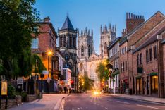
- Southwold
- England
written by
Rough Guides Editors
Strictly speaking, East Anglia is made up of just three counties – Suffolk, Norfolk and Cambridgeshire, which were settled in the fifth century by Angles from today’s Schleswig-Holstein – but it has come to be loosely applied to parts of Essex too. As a region it’s renowned for its wide skies and flat landscapes – if you’re looking for mountains, you’ve come to the wrong place. East Anglia can surprise, nonetheless: parts of Suffolk and Norfolk are decidedly hilly, with steep coastal cliffs; broad rivers cut through the fenlands; and Norfolk also boasts some wonderful sandy beaches. Fine medieval churches abound, built in the days when this was England’s most progressive and prosperous region.
Heading into East Anglia from the south takes you through Essex, whose proximity to London has turned much of the county into an unappetizing commuter strip. Amid the suburban gloom, there are, however, several worthwhile destinations, most notably Colchester, once a major Roman town and now a likeable place with an imposing castle, and the handsome hamlets of the bucolic Stour River Valley on the Essex–Suffolk border. Essex’s Dedham is one of the prettiest of these villages, but the prime attraction hereabouts is Suffolk’s Flatford Mill, famous for its associations with the painter John Constable.
Suffolk boasts a string of pretty little towns – Lavenham is the prime example – that enjoyed immense prosperity from the thirteenth to the sixteenth century, the heyday of the wool trade. The county town of Ipswichhas more to offer than it’s given credit for, but really it’s the north Suffolk coast that holds the main appeal, especially the delightful seaside resort of Southwold and neighbouring Aldeburgh with its prestigious music festival.
Norfolk, as everyone knows thanks to Noël Coward, is very flat. It’s also one of the most sparsely populated and tranquil counties in England, a remarkable turnaround from the days when it was an economic and political powerhouse – until, that is, the Industrial Revolution simply passed it by. Its capital, Norwich, is East Anglia’s largest city, renowned for its Norman cathedral and castle; nearby are the Broads, a unique landscape of reed-ridden waterways that have been intensively exploited by boat-rental companies. Similarly popular, the Norfolk coast holds a string of busy, very English seaside resorts – Cromer and Sheringham to name but two – but for the most part it’s charmingly unspoilt, its marshes, creeks and tidal fats studded with tiny flintstone villages, most enjoyably Blakeney and Cley.
Cambridge is much visited, principally because of its world-renowned university, whose ancient colleges boast some of the finest medieval and early-modern architecture in the country. The rest of Cambridgeshire is pancake-flat fenland, for centuries an inhospitable marshland, but now rich alluvial farming land. The cathedral town of Ely, settled on one of the few areas of raised ground in the fens, is an easy and popular day-trip from Cambridge.
Given the prevailing flatness of the terrain, hiking in East Anglia is less strenuous than in most other English regions, and there are several long-distance footpaths. The main one is the Peddars Way, which runs north from Knettishall Heath, near Thetford, to the coast at Holme-next-the-Sea, near Hunstanton, where it continues east as the Norfolk Coast Path to Cromer – 93 miles in total.
On the whole, CAMBRIDGE is a much quieter and more secluded place than Oxford, though for the visitor what really sets it apart from its scholarly rival is “The Backs” – the green sward of land that straddles the languid River Cam, providing exquisite views over the backs of the old colleges. At the front, the handsome facades of these same colleges dominate the layout of the town centre, lining up along the main streets. Most of the older colleges date back to the late thirteenth and early fourteenth centuries and are designed to a similar plan, with the main gate leading through to a series of “courts,” typically a carefully manicured slab of lawn surrounded on all four sides by college residences or offices. Many of the buildings are extraordinarily beautiful, but the most famous is King’s College, whose magnificent King’s College Chapel is one of the great statements of late Gothic architecture. There are 31 university colleges in total, each an independent, self-governing body, proud of its achievements and attracting – for the most part at least – a close loyalty from its students.
Note that most colleges have restricted opening times and some impose admission charges; during the exam period (late April to early June) most of them close their doors to the public at least some of the time.
Punting is the quintessential Cambridge activity, though it is, in fact, a good deal harder than it looks. First-timers find themselves zigzagging across the water and “punt jams” are very common on the stretch of the River Cam beside The Backs in summer. Punt rental is available at several points, including the boatyard at Mill Lane (beside the Silver Street bridge), at Magdalene Bridge, and at the Garret Hostel Lane bridge at the back of Trinity College. It costs around £16/hr per person (and most places charge a deposit), with up to six people in each punt. Alternatively, you can hire a chauffeured punt from any of the rental places for about £12/hr per person.
If you visit anywhere in Essex, it should be COLCHESTER, a busy sort of place with a castle, a university and an army base, fifty miles or so northeast of London. Colchester prides itself on being England’s oldest town, and there is indeed documentary evidence of a settlement here as early as the fifth century BC. Today, Colchester makes a potential base for explorations of the surrounding countryside – particularly the Stour valley towns of Constable country, within easy reach a few miles to the north.
By the first century AD, the town was the region’s capital under King Cunobelin – better known as Shakespeare’s Cymbeline – and when the Romans invaded Britain in 43 AD they chose Colchester (Camulodunum) as their new capital, though it was soon eclipsed by London. Later, the conquering Normans built one of their mightiest strongholds in Colchester, but the conflict that most marked the town was the Civil War. In 1648, Colchester was subjected to a gruelling siege by the Parliamentarian army; after three months, during which the population ate every living creature within the walls, the town finally surrendered and the Royalist leaders were promptly executed for their pains.
At the heart of Colchester are the remains of its castle, a ruggedly imposing, honey-coloured keep, set in attractive parkland stretching down to the River Colne. Begun less than ten years after the Battle of Hastings, the keep was the largest in Europe at the time, built on the site of the Temple of Claudius. Inside the keep, a museum holds an excellent collection of Romano-British archeological finds, notably a miscellany of coins and tombstones. The museum also runs regular guided tours, giving access to the Roman vaults, the Norman chapel and the castle roof, which are otherwise out of bounds. Outside, down towards the river in Castle Park, is a section of the old Roman walls, whose battered remains are still visible around much of the town centre. They were erected after Boudicca had sacked the city and, as such, are a case of too little too late.
Perched on a mound of clay above the River Great Ouse about thirty miles south of King’s Lynn, the attractive little town of ELY – literally “eel island” – was to all intents and purposes a true island until the draining of the fens in the seventeenth century. Until then, the town was encircled by treacherous marshland, which could only be crossed with the help of the local “fen-slodgers” who knew the firm tussock paths. In 1070, Hereward the Wake turned this inaccessibility to military advantage, holding out against the Normans and forcing William the Conqueror to undertake a prolonged siege – and finally to build an improvised road floated on bundles of sticks. Centuries later, the Victorian writer Charles Kingsley resurrected this obscure conflict in his novel Hereward the Wake. He presented the protagonist as the Last of the English who “never really bent their necks to the Norman yoke and … kept alive those free institutions which were the germs of our British liberty” – a heady mixture of nationalism and historical poppycock that went down a storm.
Since then, Ely has been associated with Hereward, which is a little ridiculous as Ely is, above all else, a Norman town. The Normans built the cathedral, a towering structure visible for miles across the flat fenland landscape and Ely’s main sight. The rest of Ely is pretty enough: to the immediate north of the church is the High Street, a slender thoroughfare lined with old-fashioned shops, and the river is a relaxing spot with a riverside footpath, a tearoom or two, a small art gallery and an entertainment complex.
IPSWICH, situated at the head of the Orwell estuary, was a rich trading port in the Middle Ages, but its appearance today is mainly the result of a revival of fortunes in the Victorian era – give or take some clumsy postwar development. The two surviving reminders of old Ipswich – Christchurch Mansion and the splendid Ancient House – plus the recently renovated quayside are all reason enough to spend at least an afternoon here, and there’s also the Cornhill, the ancient Saxon marketplace and still the town’s focal point, an agreeable urban space flanked by a bevy of imposing Victorian edifices – the Italianate town hall, the old Neoclassical Post Office and the grandiose pseudo-Jacobean Lloyds building.
Straddling the canalized mouth of the River Great Ouse a mile or so before it slides into The Wash, King’s Lynn is an ancient port whose merchants grew rich importing fish from Scandinavia, timber from the Baltic and wine from France, while exporting wool, salt and corn. The good times came to an end when the focus of maritime trade moved to the Atlantic seaboard, but its port struggled on until it was reinvigorated in the 1970s by the burgeoning trade between the UK and the EU. Much of the old centre was demolished during the 1960s and as a result most of Lynn – as it’s known locally – is not especially enticing, but it does have a cluster of handsome old riverside buildings, and its lively, open-air markets attract large fenland crowds.
The first place of any note on the north Norfolk coast is Cromer, a seaside town whose steep and blustery cliffs have drawn tourists for over a century. A few miles to the west is another well-established resort, Sheringham, but thereafter the shoreline becomes a ragged patchwork of salt marshes, dunes and shingle spits which form a series of nature reserves, supporting a fascinating range of flora and fauna. It’s a lovely stretch of coast and the villages bordering it, principally Cley, Blakeney and Wells-next-the-Sea, are prime targets for an overnight stay.
A mile or so west of Cley, delightful BLAKENEY was once a bustling port exporting fish, corn and salt, and is now a lovely little place of pebble-covered cottages sloping up from a narrow harbour. Crab sandwiches are sold from stalls at the quayside, the meandering high street is flanked by family-run shops, and footpaths stretch out along the sea wall to east and west, allowing long, lingering looks over the salt marshes.
Blakeney harbour is linked to the sea by a narrow channel that wriggles its way through the salt marshes and is only navigable for a few hours at high tide. At low tide the harbour is no more than a muddy creek (ideal for a bit of quayside crabbing and mud sliding).
Depending on the tides, there are boat trips from either Blakeney or Morston quay, a mile or so to the west, to both Blakeney Point – where passengers have a couple of hours at the point before being ferried back – and to the seal colony just off the point. The main operators advertise departure times on blackboards by the quayside; you can reserve in advance with Beans Boats or Bishop’s Boats.
CLEY (more formally Cley-next-the-Sea), once a busy wool port, is now little more than a row of flint cottages and Georgian mansions set beside a narrow, marshy inlet that (just) gives access to the sea. The sea once dipped further inland, which explains why Cley’s fine medieval church of St Margaret is located half a mile to the south, at the very edge of the current village, overlooking the green. You’re near a couple of splendid nature reserves here, both excellent destinations for birdwatchers – and don’t miss the Cley Smoke House for superb locally smoked fish.
Dramatically poised on a high bluff, CROMER should be the most memorable of the Norfolk coastal resorts, but its fine aspect has long been undermined by a certain shabbiness in its narrow streets and alleys. Things are at last on the mend, with new businesses arriving to add a touch of flair, while the town council keeps a string of cliff-top mini-parks and gardens in immaculate condition.
It’s no more than the place deserves: Cromer has a long history, first as a prosperous medieval port – witness the tower of St Peter and St Paul, at 160ft the tallest in Norfolk – and then as a fashionable watering hole after the advent of the railway in the 1880s. There are three things you must do here: take a walk on the beach, stroll out onto the pier, and, of course, grab a crab: Cromer crabs are famous right across England and several places sell them, reliably fresh, and cooked and stuffed every which way.
Three rivers – the Yare, Waveney and Bure – meander across the flatlands to the east of Norwich, converging on Breydon Water before flowing into the sea at Great Yarmouth. In places these rivers swell into wide expanses of water known as “broads”, which for years were thought to be natural lakes. In fact they’re the result of extensive peat cutting, several centuries of accumulated diggings made in a region where wood was scarce and peat a valuable source of energy. The pits flooded when sea levels rose in the thirteenth and fourteenth centuries to create these Norfolk Broads, now one of the most important wetlands in Europe – a haven for many birds such as kingfishers, grebes and warblers – and one of the county’s major tourist attractions. Looking after the Broads, the Broads Authority maintains a series of information centres throughout the region.
The Norfolk Broads are crisscrossed by roads and rail lines, but the best – really the only – way to see them is by boat, and you could happily spend a week or so exploring the 125 miles of lock-free navigable waterways, visiting the various churches, pubs and windmills en route. Of the many boat rental companies, Blakes and Norfolk Broads Boating Holidays, are both well established and have rental outlets at Wroxham, seven miles northeast of Norwich – and easy to reach by train, bus and car. Prices for cruisers start at around £700 a week for four people in peak season, but less expensive, short-term rentals are widely available too. Houseboats are much cheaper than cruisers, but they are, of course, static.
Trying to explore the Broads by car is pretty much a waste of time, but cyclists and walkers can take advantage of the region’s network of footpaths and cycle trails. There are Broads Authority bike rental points dotted around the region and walkers might consider the 56-mile Weavers’ Way, a long-distance footpath that winds through the best parts of the Broads on its way from Cromer to Great Yarmouth. There are many shorter options too. As for specific sights for landlubbers and boaters alike, one prime target is Toad Hole Cottage, an old eel-catcher’s cottage holding a small exhibit on the history of the trade, which was common in the area until the 1940s. The cottage is at How Hill, close to the hamlet of Ludham, six miles east of Wroxham on the A1062. Behind the cottage is the narrow River Ant, where there are hour-long, wildlife-viewing boat trips in the Electric Eel.
The footpaths latticing Holkham Hall estate stretch as far as the A149, from where a half-mile byroad – Lady Anne’s Drive – leads north across the marshes from opposite the Victoria Hotel to Holkham Bay, which boasts one of the finest beaches on this stretch of coast, with golden sand and pine-studded sand dunes. Warblers, flycatchers and redstarts inhabit the drier coastal reaches, while waders paddle about the mud and salt flats.
One of the five largest cities in Norman England, NORWICH once served a vast hinterland of East Anglian cloth producers, whose work was brought here by river and then exported elsewhere. Its isolated position beyond the Fens meant that it enjoyed closer links with the Low Countries than with the rest of England and, by 1700, Norwich was the second richest city in the country after London. With the onset of the Industrial Revolution, however, Norwich lost ground to the northern manufacturing towns – the city’s famous mustard company, Colman’s, is one of its few industrial success stories – and this has helped preserve much of the ancient street plan and many of the city’s older buildings. Pride of place goes to the beautiful cathedral and the sterling castle, but the city’s hallmark is its medieval churches, thirty or so squat flintstone structures with sturdy towers and sinuous stone tracery round the windows. Many are no longer in regular use and are now in the care of the Norwich Historic Churches Trust, whose website describes each church in precise detail.
Norwich’s relative isolation has also meant that the population has never swelled to any great extent and today, with just 140,000 inhabitants, it remains an easy and enjoyable city. Yet Norwich is no provincial backwater. In the 1960s, the foundation of the University of East Anglia (UEA) made it more cosmopolitan and bolstered its arts scene, while in the 1980s it attracted new high-tech companies, who created something of a mini-boom, making the city one of England’s wealthiest. As East Anglia’s unofficial capital, Norwich also lies at the hub of the region’s transport network, serving as a useful base for visiting the Broads and as a springboard for the north Norfolk coast.
Of all the medieval buildings in Norwich, it’s the Cathedral that fires the imagination: a mighty, sand-coloured structure finessed by its prickly octagonal spire, it rises to a height of 315ft, second only to Salisbury Cathedral in Wiltshire. Entered via the Hostry, a glassy, well-proportioned visitor centre, the interior is pleasantly light thanks to a creamy tint in the stone and the clear glass windows of much of the nave, where the thick pillars are a powerful legacy of the Norman builders who began the cathedral in 1096. The nave’s architectural highlight is the ceiling, a finely crafted affair whose delicate and geometrically precise fan vaulting is adorned by several dozen roof bosses. Pushing on down the south (right) side of the ambulatory, you soon reach St Luke’s Chapel and the cathedral’s finest work of art, the Despenser Reredos, a superb painted panel commissioned to celebrate the crushing of the Peasants’ Revolt of 1381. Accessible from the south aisle of the nave are the cathedral’s unique cloisters. Built between 1297 and 1450, and the only two-storey cloisters left standing in England, they contain a remarkable set of sculpted bosses, similar to the ones in the main nave, but here they are close enough to be scrutinized without binoculars. The dominant theme of the fabulously intricate carving is the Apocalypse, but look out also for the bosses depicting green men, originally pagan fertility symbols.
Outside, in front of the main entrance, stands the medieval Canary Chapel. This is the original building of Norwich School, whose blue-blazered pupils are often visible during term time – the rambling school buildings are adjacent. A statue of the school’s most famous boy, Horatio Nelson, faces the chapel, standing on the green of the Upper Close, which is guarded by two ornate and imposing medieval gates, Erpingham and, a few yards to the south, Ethelbert. Beside the Erpingham gate is a memorial to Edith Cavell, a local woman who was a nurse in occupied Brussels during World War I. She was shot by the Germans in 1915 for helping allied prisoners to escape, a fate that made her an instant folk hero; her grave is outside the cathedral ambulatory. Both gates lead onto the old Saxon marketplace, Tombland, a wide and busy thoroughfare whose name derives from the Saxon word for an open space.
From Blackfriars Hall, it’s a short walk through to the city’s Market Place, site of one of the country’s largest open-air markets (closed Sun), with stalls selling everything from bargain-basement clothes to local mussels and whelks. Four very different but equally distinctive buildings oversee the market’s stripy awnings, the oldest of them being the fifteenth-century Guildhall, a capacious flint and stone structure begun in 1407. Opposite, commanding the heights of the marketplace, are the austere City Hall, a lumbering brick pile with a landmark clocktower that was built in the 1930s in a Scandinavian style, and The Forum, a large and flashy, glassy structure completed in 2001. The latter is home to the city’s main library and the tourist office. On the south side of Market Place is the finest of the four buildings, St Peter Mancroft, whose long and graceful nave leads to a mighty stone tower, an intricately carved affair surmounted by a spiky little spire.
Back outside and just below the church is Gentlemen’s Walk, the town’s main promenade, which runs along the bottom of the marketplace and abuts the Royal Arcade, an Art Nouveau extravagance from 1899. The arcade has been beautifully restored to reveal the swirling tiling, ironwork and stained glass.
For more inspiration and practical information read our 15 reasons to visit Norfolk.
Six miles or so north of Colchester, the Stour River Valley forms the border between Essex and Suffolk, and signals the beginning of East Anglia proper. The valley is dotted with lovely little villages, where rickety, half-timbered Tudor houses and elegant Georgian dwellings cluster around medieval churches, proud buildings with square, self-confident towers. The Stour’s prettiest villages are concentrated along its lower reaches – to the east of the A134 – in Dedham Vale, with Dedham the most appealing of them all. The vale is also known as “Constable Country”, as it was the home of John Constable, one of England’s greatest artists, and the subject of his most famous paintings. Inevitably, there’s a Constable shrine – the much-visited complex of old buildings down by the river at Flatford Mill. Elsewhere, the best-preserved of the old south Suffolk wool towns is Lavenham; nearby Sudbury has a fine museum, devoted to the work of another talented English artist, Thomas Gainsborough.
The villages along the River Stour and its tributaries were once busy little places at the heart of East Anglia’s medieval weaving trade. By the 1490s, the region produced more cloth than any other part of the country, but in Tudor times production shifted to Colchester, Ipswich and Norwich and, although most of the smaller settlements continued spinning cloth for the next three hundred years or so, their importance slowly dwindled. Bypassed by the Industrial Revolution, south Suffolk had, by the late nineteenth century, become a remote rural backwater, an impoverished area whose decline had one unforeseen consequence: with few exceptions, the towns and villages were never prosperous enough to modernize, and the architectural legacy of medieval and Tudor times survived.
Constable went to school in DEDHAM, just upriver from Flatford Mill and one of the region’s prettiest villages, its wide and lazy main street graced by a handsome medley of old timber-framed houses and Georgian villas. Day-trippers arrive here by the coach load throughout the summer.
“I associate my careless boyhood with all that lies on the banks of the Stour,” wrote John Constable, who was born in East Bergholt, nine miles northeast of Colchester in 1776. The house in which he was born has long since disappeared, so it has been left to FLATFORD MILL, a mile or so to the south, to take up the painter’s cause. The mill was owned by his father and was where Constable painted his most celebrated canvas, The Hay Wain (now in London’s National Gallery), which created a sensation when it was exhibited in Paris in 1824. To the chagrin of many of his contemporaries, Constable turned away from the landscape painting conventions of the day, rendering his scenery with a realistic directness that harked back to the Dutch landscape painters of the seventeenth century.
The mill itself – not the one he painted, but a Victorian replacement – is not open to the public and neither is neighbouring Willy Lott’s Cottage, which does actually feature in The Hay Wain, but the National Trust has colonized several local buildings, principally Bridge Cottage.
LAVENHAM, eight miles northeast of Sudbury, was once a centre of the region’s wool trade and is now one of the most visited villages in Suffolk, thanks to its unrivalled ensemble of perfectly preserved half-timbered houses. In outward appearance at least, the whole place has changed little since the demise of the wool industry, owing in part to a zealous local preservation society, which has carefully maintained the village’s antique appearance. Lavenham is at its most beguiling in the triangular Market Place, an airy spot flanked by pastel-painted, medieval dwellings whose beams have been warped into all sorts of wonky angles by the passing of the years.
The Suffolk coast feels detached from the rest of the county: the road and rail lines from Ipswich to the seaport of Lowestoft funnel traffic a few miles inland for most of the way, and patches of marsh and woodland make the separation still more complete. The coast has long been plagued by erosion and this has contributed to the virtual extinction of the local fishing industry, and, in the case of Dunwich, almost destroyed the whole town. What is left, however, is undoubtedly one of the most unspoilt shorelines in the country – if, that is, you set aside the Sizewell nuclear power station. Highlights include the sleepy isolation of minuscule Orford and several genteel resorts, most notably Southwold and Aldeburgh, which have both evaded the lurid fate of so many English seaside towns. There are scores of delightful walks around here too, easy routes along the coast that are best followed with either the appropriate OS Explorer Map or the simplified footpath maps available at most tourist offices. The Suffolk coast is also host to East Anglia’s most compelling cultural gathering, the three-week-long Aldeburgh Festival, which takes place every June.
Well-heeled ALDEBURGH, just along the coast from Orford, is best known for its annual arts festival, the brainchild of composer Benjamin Britten (1913–76), who is buried in the village churchyard alongside the tenor Peter Pears, his lover and musical collaborator. They lived by the seafront in Crag House on Crabbe Street – named after the poet, George Crabbe, who provided Britten with his greatest inspiration – before moving to a large house a few miles away.
Outside of June, Aldeburgh is a relaxed and low-key coastal resort, with a small fishing fleet selling its daily catch from wooden shacks along the pebbled shore. Aldeburgh’s slightly old-fashioned/local shop appearance is fiercely defended by its citizens, who caused an almighty rumpus – Barbours at dawn – when Maggi Hambling’s 13ft-high Scallop sculpture appeared on the beach in 2003. Hambling described the sculpture as a conversation with the sea and a suitable memorial to Britten; many disgruntled locals compared it to a mantelpiece ornament gone wrong.
Aldeburgh’s wide High Street and its narrow side streets run close to the beach, but this was not always the case – hence their quixotic appearance. The sea swallowed much of what was once an extensive medieval town long ago and today Aldeburgh’s oldest remaining building, the sixteenth-century, red-brick, flint and timber Moot Hall, which began its days in the centre of town, now finds itself on the seashore. Several footpaths radiate out from Aldeburgh, with the most obvious trail leading north along the coast to Thorpeness, and others going southwest to the winding estuary of the River Alde.
Born in Lowestoft in 1913, Benjamin Britten was closely associated with Suffolk for most of his life. The main break was during World War II when, as a conscientious objector, Britten exiled himself to the USA. Ironically enough, it was here that Britten first read the work of the nineteenth-century Suffolk poet, George Crabbe, whose The Borough, a grisly portrait of the life of the fishermen of Aldeburgh, was the basis of the libretto of Britten’s best-known opera, Peter Grimes, which was premiered in London in 1945 to great acclaim. In 1948, Britten launched the Aldeburgh Festival as a showpiece for his own works and those of his contemporaries. He lived in the village for the next ten years, during which time he completed much of his finest work as a conductor and pianist. For the rest of his life he composed many works specifically for the festival, including his masterpiece for children, Noye’s Fludde, and the last of his fifteen operas, Death in Venice.
By the mid-1960s, the festival had outgrown the parish churches in which it began, and moved into a collection of disused malthouses, five miles west of Aldeburgh on the River Alde, just south of the small village of Snape. The complex, the Snape Maltings were subsequently converted into one of the finest concert venues in the country and, in addition to the concert hall, there are now recording studios, galleries, a tearoom, and a pub, the Plough & Sail.
The Aldeburgh Festival takes place every June for two and a half weeks. Core performances are still held at the Maltings, but a string of other local venues are pressed into service as well. Throughout the rest of the year, the Maltings hosts a wide-ranging programme of musical and theatrical events, including the three-day Britten Festival in October. For more information, contact Aldeburgh Music, which operates two box offices, one at Snape Maltings, the other on Aldeburgh High Street in premises it shares with the tourist office. Tickets for the Aldeburgh Festival usually go on sale to the public towards the end of March, and sell out fast for the big-name recitals.
Some twenty miles from Ipswich, on the far side of Tunstall Forest, two medieval buildings dominate the tiny, eminently appealing village of ORFORD. The more impressive is the twelfth-century castle, built on high ground by Henry II, and under siege within months of its completion from Henry’s rebellious sons. Most of the castle disappeared centuries ago, but the lofty keep remains, its striking stature hinting at the scale of the original fortifications. Orford’s other medieval edifice is St Bartholomew’s church, where Benjamin Britten premiered his most successful children’s work, Noye’s Fludde, as part of the 1958 Aldeburgh Festival.
Perched on robust cliffs just to the north of the River Blyth, SOUTHWOLD had become, by the sixteenth century, Suffolk’s busiest fishing port. Eventually, however, it lost most of its fishery to neighbouring Lowestoft and today, although a small fleet still brings in herring, sprats and cod, the town is primarily a seaside resort, a genteel and eminently appealing little place with none of the crassness of many of its competitors. There are fine Georgian buildings, a long sandy beach, open heathland, a dinky harbour and even a little industry – in the shape of the Adnams brewery – but no burger bars and certainly no amusement arcades. This gentility was not to the liking of George Orwell, who lived for a time at his parents’ house at 36 High St (a plaque marks the spot); who knows what he might have made of Southwold’s major music festival, Latitude, which spreads over four days in the middle of July with happy campers grubbing down in Henham Park beside the A12 about five miles west of town.
Use Rough Guides' trusted partners for great rates
written by
Rough Guides Editors