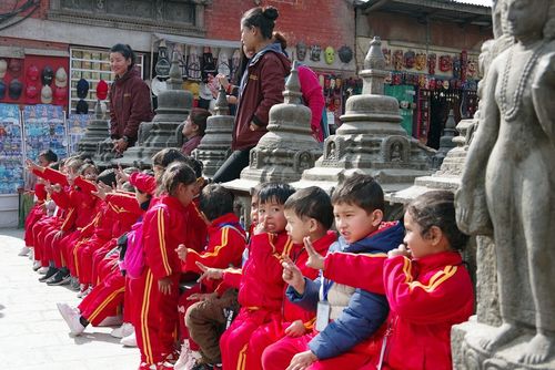
Agriculture in the Kathmandu Valley
Even as the capital’s swelling population threatens to fill the Kathmandu Valley in lot after lot of detached, blockhouse, commuter concrete, the Jyapus, indigenous Newari farmers, continue to live in huddled-up, brick-built towns, digging their fields by hand in the time-honoured fashion: with a distinctive two-handed spade called kodaalo (ku in Newari). The valley’s soil repays such labour-intensive care: it is endowed with a fertile, black clay called kalimati, a by-product of sediment from the prehistoric lake, and is low enough in elevation to support two or even three main crops a year. Rice is seeded in special irrigated beds shortly before the first monsoon rains in June, and seedlings are transplanted into flooded terraces no later than the end of July. Normally women do this job, using their toes to bed each shoot in the mud. The stalks grow green and bushy during the summer, turning a golden brown and producing mature grain by October.
At harvest time sheaves are spread out on paved roads for cars to loosen the kernels, and then run through portable hand-cranked threshers or bashed against rocks. The grain is gathered in bamboo trays (nanglo) and tossed in the wind to winnow away the chaff, or, if there’s no wind, nanglo can be used to fan away the chaff. Some sheaves are left in stacks to ferment for up to two weeks, producing a soft food known as hakuja, or “black” rice. The rice dealt with, terraces are then planted with winter wheat. Unfortunately, for tourists, the period of planting, when the soil looks bare and brown, coincides with the peak tourist season. The wheat is harvested in April or May, after which a third crop of pulses or maize can often be squeezed in. Vegetables are raised year-round at the edges of plots or, in the case of squashes, festooned along fences and on top of shrubs and low trees.
Most Kathmandu Valley farmers are tenants, and have to pay huge proportions of their harvests in rent. But their lot has improved in the past generation: land reform in the 1950s and 1960s was relatively diligently implemented near the capital, helping to get landlords and moneylenders off the backs of small farmers, and the Maoist government has also forced landowners to break up and sell off larger holdings. However, the traditional Newari system of inheritance, in which family property is divided up among the sons, means that landholdings actually get smaller with each generation. That presents a contrasting problem: farms that are too small to make mechanical equipment worthwhile, necessitating labour-intensive methods and keeping productivity low.
Bhaktapur
In the soft, dusty light of evening the old city of Bhaktapur, with its pagoda roofs and its harmonious blend of wood, mud-brick and copper, looked extraordinarily beautiful. It was as though a faded medieval tapestry were tacked on to the pale tea-rose sky. In the foreground a farmhouse was on fire, and orange flames licked like liquescent dragon’s tongues across the thatched roof. One thought of Chaucer’s England and Rabelais’s France; of a world of intense, violent passions and brilliant colour, where sin was plentiful but so were grace and forgiveness …
Charlie Pye-Smith Travels in Nepal
Kathmandu’s field of gravity weakens somewhere east of the airport; beyond, you fall into the rich atmosphere of Bhaktapur, also known as Bhadgaun.
Rising in a tight mass of warm brick out of the fertile fields of the valley, the city looks something like Kathmandu must have done before the arrival of the modern world. During the day, tour groups and persistent “student” guides mill about enthusiastically in the main squares, but after hours, or in among the maze of backstreets, it would be hard not to feel the pulse of this quintessential Newari city.
This is one of the Kathmandu Valley’s most evocative stops on a Nepal guided tour, especially for travellers drawn to traditional architecture and everyday street life.
In among Bhaktapur’s herringbone-paved streets and narrow alleys, women wash at public taps, men in traditional dress lounge in the many sattal, or covered loggias, peasants squat by the road selling meagre baskets of vegetables, and worshippers assiduously attend neighbourhood shrines.
And everywhere the burnt-peach hue of bricks is offset by the deep brown of intensely carved wood, the essential materials of the Newari architects.
Physically, the city drapes across an east–west fold in the valley, with a single pedestrianized road as its spine, and its southern fringe sliding down towards the sluggish Hanumante Khola. Owing to a gradual westward drift, the city has two centres (residents of the two halves stage a boisterous tug-of-war during the city’s annual Bisket festival) and three main squares. In the west, Durbar Square and Taumadhi Tol dominate the post-fifteenth-century city, while Tachapal Tol (Dattatreya Square) presides over the older east end.
Brief history
The “City of Devotees” was probably founded in the ninth century, and by 1200 it was ruling Nepal. In that year Bhaktapur witnessed the launch of the Malla era when, according to the Nepali chronicles, King Aridev, upon being called out of a wrestling bout to hear of the birth of a son, bestowed on the prince the hereditary title Malla (“wrestler”). To this day, beefy carved wrestlers are the city’s trademark temple guardians. Bhaktapur ruled the valley until 1482, when Yaksha Malla divided the kingdom among his three sons, setting in train three centuries of continuous squabbling.
It was a Bhaktapur king who helped to bring the Malla era to a close in 1766 by inviting Prithvi Narayan Shah, the Gorkha leader, to aid him in a quarrel against Kathmandu. Seizing on this pretext, Prithvi Narayan conquered the valley within three years, Bhaktapur being the last of the three capitals to surrender.
Well over half of Bhaktapur’s population is from the agricultural Jyapu caste of the Newars, and it may well be the city’s tightly knit, inward-looking nature that has saved it from the free-for-all expansion that overwhelms Kathmandu. Thanks to a long-term restoration and sanitation programme, and to the policies of its independent-minded municipal council, much of the city is pedestrianized. Temples and public shelters have been restored with the money raised from the city’s entrance fee, and new buildings are now required to follow traditional architectural styles. This is one Nepali city that has got its act together, and it wears its status as a UNESCO World Heritage Site proudly.
King curd
Bhaktapur’s culinary speciality, famed throughout Nepal, is juju dhau, or “king of curds”. Made from naturally sweet buffalo milk, it is boiled up in an iron pot along with cloves, cardamom, coconut and cashew – sugar, properly, isn’t added at all – and then cooled slowly, with the addition of an older batch to introduce the lactobacillus that makes it curdle. Most tourist restaurants serve it, at a price, but you can find it anywhere you see the painted, cartoon sign of a full bowl. A number of shops on the main road between the minibus park and Durbar Square serve it in the traditional clay bhingat bowls for around Rs30. There’s no added water, and it shouldn’t pose any health risk. Whether or not you’re getting the real, natural product, or a fake made using powdered milk, sugar and a freezer, can’t be guaranteed, however. One test is said to be to upend the bowl: real king curd won’t fall out.
Boudha
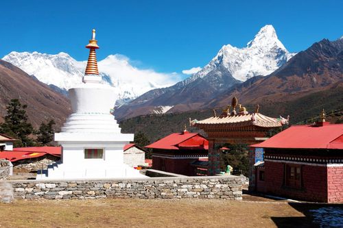
The great white stupa at BOUDHA (or BOUDHANATH), about 5km northeast of central Kathmandu, is the swollen sacred heart of a thriving Tibetan Buddhist community. One of the world’s largest stupas – Tibetans call it simply Chorten Chempo, “Great Stupa” – it is also the most important Tibetan Buddhist monument outside Tibet. Since 1959, Boudha has been the focus for Tibetan exiles in Nepal, but it has been a sacred site on the Kathmandu–Tibet trade route for centuries. The 10km corridor from Pashupatinath to Sankhu was known as the auspicious zone of siddhi (supernatural beings), and Boudha was – and still is – its biggest, most auspicious landmark.
If you're planning a trip to Nepal, time your visit to Boudhanath Stupa for early morning or dusk. This is when the atmosphere is at its most magical — monastery music fills the air, and monks, locals, and pilgrims perform kora, circling the stupa with quiet devotion.
During the day, the souvenir shops and cafés surrounding the stupa can feel more touristy than spiritual. And if you wander north, the charm quickly fades — Boudha’s boomtown is a messy sprawl of traffic, new construction, and litter-strewn lanes, a stark contrast to the serenity at the stupa’s heart.
Some history
Traditions differ as to the stupa’s origins. A Tibetan text relates how a daughter of Indra stole flowers from heaven and was reassigned to earth as a lowly poultryman’s daughter, yet prospered and decided to use some of her wealth to build a stupa to honour a mythical Buddha of a previous age. She petitioned the king, who cynically granted her only as much land as could be covered by a buffalo hide. Undaunted, the woman cut the hide into thread-thin strips and joined them end to end to enclose a gigantic area.
The Newari legend has a firmer historical grounding, involving a drought that struck Kathmandu during the reign of the early Lichhavi king, Vrisadev. When court astrologers advised that only the sacrifice of a virtuous man would bring rain, Vrisadev commanded his son Mandev to go to the royal well on a moonless night and decapitate the shrouded body he would find there. Mandev obeyed, only to find to his horror that he had sacrificed his own father. When he asked the goddess Bajra Yogini of Sankhu how to expiate his guilt, she let fly a bird and told him to build a stupa at the spot where it landed, which was Boudha.
Whatever its legendary origins, it’s possible that the core of the stupa dates as early as the fifth century AD, and it’s almost certain that it encloses holy relics, perhaps parts of the Buddha’s body (bones, hair, teeth) and objects touched or used by him, along with sacred texts and other ritual objects. The stupa has been sealed for centuries, of course, so no one knows exactly what lies within, but the relics are held responsible for the stupa’s power, and its ability to command veneration.
Boudha festivals
If you want an extra helping of Tibetan culture, go to Boudha during the festival of Losar in February or March, when the community hosts the biggest Tibetan New Year celebration in Nepal. Other busy times are Buddha Jayanti (the Buddha’s birthday), held on the full moon of April–May, when an image of the Buddha is paraded around the stupa aboard an elephant, and the full moon of March–April, when ethnic Tamangs – the original guardians of the stupa – converge here to arrange marriages, and hundreds of eligible brides are sat around the stupa for inspection. Full moon and new moon days in general attract more pilgrims, since acts of worship earn more merit on these days.
Boudha’s dharma scene
Boudha’s Western community is well established, though to become a part of it you need either an introduction or a lot of time, since serious Western students of dharma tend to regard tourists as spiritual interference. But as those in the know say, if you’re ready you will find a teacher here. Some will go on to warn enthusiastic newcomers that there are good teachers and bad, and Buddhism is big business in Boudha. Still, many Westerners rate it as the best place in the world to study Tibetan Buddhism. All four sects are well represented, and the main alternative, Dharamsala in India, arguably has a politically rather than spiritually charged atmosphere.
A good way to start is to stay at a gompa guesthouse (most monasteries operate them, and they are open to all), to check restaurant or guesthouse notice boards, or to sample some of the alternative treatments on offer everywhere – from massage to Tibetan medicine. You could also go straight to a monastery: puja ceremonies are open to all, and most rinpoches (or “respected teachers”) at Boudha give occasional open talks – with or without English translation. Many also agree to one-on-one meetings to those who show a keen interest.
Some monasteries are particularly oriented towards Westerners; the following are worth checking out. Note that some of the more popular, better-funded monasteries operate grander satellite institutes in the countryside.
Teaching Gompa in Boudha
Jamchen Lhakhang Gompa The Sakya school is represented at Boudha by this monastery, headed by the English-speaking Shabdrung Ngawang Kyenrab Rinchen Paljor; the monastery sponsors the Boudha-based International Buddhist Academy (w internationalbuddhistacademy.org), which offers an annual ten-day retreat in September, and four- and eight-week Buddhist philosophy and Tibetan-language courses.
Shechen Gompa wshechen.org. The death in 1991 of the revered Dilgo Khyentse of Shechen Tennyi Dargyeling, the “Bhutanese Monastery”, left a large gap, but it is being filled by his grandson, the current abbot, Shechen Rabjam Rinpoche, who teaches courses in English.
Shedrub Ling Gompa (aka the “The White Monastery”) w shedrub.org. Perennially popular among the dharma set, the Ka Nying Shedrub Ling Gompa holds a regular Saturday morning talk in English, and every November, the English-speaking abbot Chökyi Nyima Rinpoche runs ten-day seminars. The monastery is affiliated to Kathmandu University for longer degree programmes.
Shelkar Chode Gompa 400m west of the stupa, facing the Hyatt Regency Hotel; w lamawangdu.org. Lama Tsering Wangdu Rinpoche holds open sessions most mornings from 7.30–11am; visitors can also attend the remarkable Chöd ritual, a tantric, symbolic offering of the body performed on the 10th and 25th of the Tibetan month.
Thrangu Tashi Choeling Gompa w rinpoche.com. Thrangu Rinpoche attracts many Western students, though usually to his grand-scale temple and teaching complex at Namobuddha, rather than this relatively modest monastery in Boudha itself.