The ferry to Hornstrandir
Every Friday and Sunday, between mid-June and mid-August, a boat sails from the harbour in Norðurfjörður to Reykjarfjörður and Látravík, providing access to the remote east coast of Hornstrandir. From both destinations it is then possible to hike west to meet up with the boats which sail across to Ísafjörður from Hesteyri among other places. Schedules and further information are available at strandferdir.is.
Tip from Rough Guides: also learn about the best ways to get to Iceland.
Hiking between Hesteyri and Aðalvík
From Læknishúsið guesthouse in Hesteyri, one of the standout walks on a Westfjords trip, a clear path follows the course of a river up the hillside. This route is actually the old road that once led west to the now abandoned settlement of Slettá. At the top, the trail crosses an extensive rockfield that can be slow going, and even in July there is often a surprising amount of snow. Follow the cairns across the rocks until the track descends into sandy Aðalvík, where the final stretch can be boggy. At the foot of the hill, cross a shallow river to reach the beach and the handful of houses at Látrar on the eastern end of Aðalvík bay, or Sæból on the western edge, both surrounded by snowy mountains. To retrace your steps, cross the river behind the beach, aim for the single house on the riverbank, then climb the hill to the right to regain the rockfield plateau and continue back to Hesteyri. The round trip is 12 km and takes around four hours.
Hornstrandir hiking practicalities
Thanks to Hornstrandir’s exposed location on the edge of the Greenland Sea, the weather is especially unpredictable, and hiking here needs plenty of careful planning. Deep snow often lies on the ground until July and snow showers are not uncommon even in July and August. Fog, too, can be a particular problem. Also, because there are no functioning settlements here – those marked on maps are farm buildings, or the remains of farm buildings only – you must be prepared for emergencies if you come to hike. It’s essential to bring the following equipment: a sturdy tent and warm sleeping bag, waterproof clothing and boots, more food than you’ll need in case of unforeseen delays (there are no shops or facilities anywhere on the peninsula, except for the guesthouse at Hesteyri), a compass and Landmælingar Íslands 1:100,000 Hornstrandir hiking map.
Although many routes are marked on the map as clearly defined, this is often not the case in reality; in poor weather conditions it can be all too easy to lose the path, so make sure that you can use a compass properly before setting out. Remember, too, that in June and July it doesn’t get dark here, which means you can extend your hiking time if needed. Mobile phones do not work in Hornstrandir, but there are landline phones for use in emergencies in the orange shelters dotted around the coast and marked on maps. Take extra care if you’re crossing tidal flats, or rounding headlands at low tide, as the going can often be very boggy. There are no footbridges in Hornstrandir, so bring an old pair of running shoes to cross rivers and streams – and be prepared to grit your teeth against the bitingly cold water.
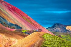
Top image: Mountaine Landscape, Hornstrandir National Park, Iceland © Bildagentur Zoonar GmbH/Shutterstock