Blackpool
Shamelessly brash BLACKPOOL is the archetypal British seaside resort, its “Golden Mile” of piers, amusement arcades, tram and donkey rides, fish-and-chip shops, candyfloss stalls, fun pubs and bingo halls making no concessions to anything but lowbrow fun of the finest kind. It was the coming of the railway in 1846 that made Blackpool what it is today: Blackpool’s own “Eiffel Tower” on the seafront and other refined diversions were built to cater to the tastes of the first influx of visitors, but it was the Central Pier’s “open-air dancing for the working classes” that heralded the crucial change of accent. Suddenly Blackpool was favoured destination for the “Wakes Weeks”, when whole Lancashire mill towns descended for their annual holiday.
With seven miles of beach – the tide ebb is half a mile, leaving plenty of sand at low tide – a revamped prom and an increasingly attractive, gentrified centre, there is more to Blackpool than just amusements. Where other British holiday resorts have suffered from the rivalry of cheap foreign packages, Blackpool has gone from strength to strength. Underneath the populist veneer there’s a sophisticated marketing approach, which balances ever more elaborate rides and public art installations with well-grounded traditional entertainment. And when other resorts begin to close up for the winter, Blackpool’s main season is just beginning, as more than half a million light bulbs create the Illuminations that decorate the prom from the beginning of September to early November.
Book tickets and tours in Blackpool.
Accommodation
Bed-and-breakfast prices are generally low (from £25 per person, even less on a room-only basis or out of season), but rise at weekends and during the Illuminations. To avoid the noisy crowds in peak season, make for the peace and quiet (an unusual request in Blackpool, it has to be said) along the North Shore, beyond North Pier (the grid west of Warbreck Hill Road has hundreds of options).
Book tickets and tours in Blackpool.
Blackpool Pleasure Beach
The major draw in town is
Blackpool Pleasure Beach
on the South Promenade, just south of South Pier. Entrance to the amusement park is free, but you’ll have to fork out for the superb array of white-knuckle rides including the 235ft-high “Big One”. The wonderful antique wooden roller coasters (“woodies” to aficionados) may seem like kids’ stuff, but each is unique – the original “Big Dipper” was invented at Blackpool in 1923 and still thrills, as does the “Grand National” (1935). Recuperate in the park’s champagne and oyster bar, which adds a bit of class to the otherwise relentless barrage of fairground noise, shrieking, jangling and fast food.
Book tickets and tours in Blackpool.
Blackpool – behind the scenes
There is, after all, an alternative Blackpool – one of history, heritage and even a spot of culture. Scene of party political conferences over the decades, the Winter Gardens opened to fanfares in 1878. Among the motley array of cafés, bars and amusements, seek out the extraordinary Spanish Hall Suite, and the Opera House honours board – Lillie Langtry, George Formby and Vera Lynn are all present. From in front of the Opera House, follow Abingdon Street to Queen Street and the porticoed Central Library, next to which the Grundy Art Gallery might tempt you in to see its Victorian oils and watercolours, contemporary art and special exhibitions. North Pier, the first pier to be opened (1863) on the Blackpool seafront, is now a listed building. Head northbound from here on the tram to the Imperial Hotel, whose wood-panelled No. 10 Bar is covered with photographs and mementos of every British prime minister since Lloyd George.
Book a ticket for the Best of London day tour.
Nightlife and entertainment
Blackpool has a plethora of theme bars and any number of places for karaoke or dancing. Family-orientated fun revolves around musicals, veteran TV comedians, magicians, ice dance, tribute bands, crooners and stage spectaculars put on at a variety of end-of-pier and historic venues.
Book tickets and tours in Blackpool.
Chester
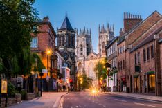
CHESTER, forty miles southwest of Manchester across the Cheshire Plain, is home to a glorious two-mile ring of medieval and Roman walls that encircles a kernel of Tudor and Victorian buildings, all overhanging eaves, mini-courtyards, and narrow cobbled lanes, which culminate in the raised arcades called the “Rows”. The centre of the city is full of easy charms that can be explored on foot, and taken altogether, Chester has enough in the way of sights, restaurants and atmosphere to make it an enjoyable base for a day or two.
Book a private tour to St Paul’s Cathedral and the Tower of London.
Book tickets and tours in Chester.
The city walls
East of the cathedral, steps provide access to the top of the city walls – a two-mile girdle of medieval and Roman handiwork that’s the most complete in Britain, though in places the wall is barely above street level. You can walk past all its towers, turrets and gateways in an hour or so, and most have a tale or two to tell. The fifteenth-century King Charles Tower in the northeast corner is so named because Charles I stood here in 1645 watching his troops being beaten on Rowton Moor, two miles to the southeast, while the earlier Water Tower at the northwest corner, once stood in the river – evidence of the changes brought about by the gradual silting of the River Dee. South from the Water Tower you’ll see the Roodee, England’s oldest racecourse, laid out on a silted tidal pool where Roman ships once unloaded wine, figs and olive oil from the Mediterranean and slate, lead and silver from their mines in North Wales. Races are still held here throughout the year.
Book a private tour to St Paul’s Cathedral and the Tower of London.
The Isle of Man
The Isle of Man, almost equidistant from Ireland, England, Wales and Scotland, is one of the most beautiful spots in Britain, a mountainous, cliff-fringed island just 33 miles by thirteen. There’s peace and quiet in abundance, walks around the unspoilt hundred-mile coastline, rural villages and steam trains straight out of a 1950s picture book – a yesteryear ensemble if ever there was one.
Many true Manx inhabitants, who comprise a shade under fifty percent of its 80,000 population, insist that the Isle of Man is not part of England, nor even of the UK. Indeed, although a Crown dependency, the island has its own government, Tynwald, arguably the world’s oldest democratic parliament, which has run continuously since 979 AD. To further complicate matters, the island maintains a unique associate status in the EU, and also has its own sterling currency (worth the same as the mainland currency), its own laws, an independent postal service, and a Gaelic-based language which is taught in schools and seen on dual-language road signs.
All roads lead to the capital, Douglas, the only town of any size. From the summit of Snaefell, the island’s highest peak, you get an idea of the island’s varied scenery, the finest parts of which are to be found in the seventeen officially designated National Glens. Most of these are linked by the 100-mile Raad Ny Foillan (Road of the Gull) coastal footpath, which passes several of the island’s numerous hill forts, Viking ship burials and Celtic crosses. Scenery aside, the main tourist draw is the TT (Tourist Trophy) motorcycle races (held in the two weeks around the late May bank holiday), a frenzy of speed and burning rubber that’s shattered the island’s peace annually since 1907.
The Calf of Man
It is worth making the effort to visit the Calf of Man, a craggy, heath-lined nature reserve lying off the southwest tip of the Isle of Man, where resident wardens monitor the seasonal populations of kittiwakes, puffins, choughs, razorbills, shags, guillemots and others, and grey seals can be seen all year round basking on the rocks.
Charter boats leave from Port St Mary, but the most reliable scheduled service (weather permitting) is from Port Erin pier; call in advance as numbers are limited and weather conditions affect schedules. You can also sea kayak around this spectacular coast. Adventurous Experiences run trips from evening paddles to full-day excursions – no experience is required.
Tynwald Day
The trans-island A1 follows a deep twelve-mile-long furrow between the northern and southern ranges from Douglas to Peel. A hill at the crossroads settlement of ST JOHN’S, nine miles along, is the original site of Tynwald, the ancient Manx government, which derives its name from the Norse Thing Völlr, meaning “Assembly Field”. Nowadays the word refers to the Douglas-based House of Keys and Legislative Council, but acts passed in the capital only become law once they have been proclaimed here on July 5 (ancient Midsummer’s Day) in an annual open-air parliament that also hears the grievances of the islanders.
Until the nineteenth century the local people arrived with their livestock and stayed a week or more – in true Viking fashion – to thrash out local issues, play sports, make marriages and hold a fair. Now Tynwald Day begins with a service in the chapel, followed by a procession, a fair and concerts.
Lancaster and around
LANCASTER, Lancashire’s county town, dates back at least as long ago as the Roman occupation, though only scant remains survive from that period. A Saxon church was later built within the ruined Roman walls as Lancaster became a strategic trading centre, and by medieval times a castle had been built on the heights above the river. Lancaster became an important port on the slave trade triangle, and it’s the Georgian buildings from that time – especially those around the castle – that give the town much of its character. Many people choose to stay here on the way to the Lakes or Dales to the north; and it’s an easy side-trip the few miles west to the resort of Morecambe and to neighbouring Heysham village, with its ancient churches, or east through the Forest of Bowland.
Book a private tour to St Paul’s Cathedral and the Tower of London.
On your bike
Lancaster promotes itself as a cycling centre, and miles of canal towpaths, old railway tracks and riverside paths provide excellent traffic-free routes around the Lune estuary, Lancaster Canal and Ribble Valley. Typical is the easy riverside path to the Crook O’Lune beauty spot, where you can reward yourself with a bacon buttie and an Eccles cake at Woodies’ famous snack bar.
The Forest of Bowland
The remote Forest of Bowland, designated an Area of Outstanding Natural Beauty, is a picturesque drive east from Lancaster. The name forest is used here in its traditional sense of “a royal hunting ground” – it’s a captivating landscape of remote fells and farmland with plenty of walks and populated by rare birds like the golden plover, short-eared owl, snipe and merlin. Head east on the A683, turning off towards High Bentham; once at the village turn right at the sign for the station and you begin the fifteen-mile slog down an old drovers’ track (now a very minor road) known as the Trough of Bowland. This winds through heather- and bracken-clad hills before ending up at the compact village of Slaidburn. If you’ve got time, it’s worth pushing ahead to Clitheroe, a tidy little market town overlooked by a Norman keep.
Lancaster Castle
The site of
Lancaster Castle
has been the city’s focal point since Roman times. The Normans built the first defences here, at the end of the eleventh century – two hundred years later it became a
crown court
, a role it maintains today. Currently, about a quarter of the battlemented building can be visited on an entertaining hour-long tour, though court sittings sometimes affect the schedules.
Morecambe
The seaside resort of MORECAMBE lies five miles west of Lancaster – there’s a pleasant cycle path between the two, and bus and train services that can whizz you there in ten minutes. The sweep of the bay is the major attraction, with the Lake District fells visible beyond, while the Stone Jetty features bird motifs and sculptures – recognizing Morecambe Bay as Britain’s most important wintering site for wildfowl and wading birds. A little way along the prom stands the statue of one of Britain’s most treasured comedians – Eric Bartholomew, who took the stage name Eric Morecambe when he met his comedy partner, Ernie Wise.