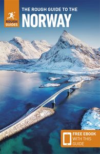
Arctic phenomena
On and above the Arctic Circle, an imaginary line drawn round the earth at latitude 66.5 degrees north, there is a period around midsummer during which the sun never makes it below the horizon, even at midnight – hence the midnight sun. On the Arctic Circle itself, this only happens on one night of the year – at the summer solstice – but the further north you go, the greater the number of nights without darkness: in Bodø, it’s from the first week of June to early July; in Tromsø from late May to late July; in Alta, from the third week in May to the end of July; in Hammerfest, mid-May to late July; and in Nordkapp, early May to the end of July. Obviously, the midnight sun is best experienced on a clear night, but fog or cloud can turn the sun into a glowing, red ball – a spectacle that can be wonderful but also strangely uncanny. All the region’s tourist offices have the exact dates of the midnight sun, though note that these are calculated at sea level; climb up a hill and you can extend the dates by a day or two. The converse of all this is the polar night, a period of constant darkness either side of the winter solstice; again the further north of the Arctic Circle you are, the longer this lasts.
The Arctic Circle also marks the typical southern limit of the northern lights, or aurora borealis, though this extraordinary phenomenon has been seen as far south as latitude 40 degrees north – roughly the position of New York or Ankara. Caused by the bombardment of the atmosphere by electrons, carried away from the sun by the solar wind, the northern lights take various forms and are highly mobile – either flickering in one spot or travelling across the sky. At relatively low latitudes hereabouts, the aurora is tilted at an angle and is often coloured red – the sagas tell of Vikings being half scared to death by them – but nearer the pole, they hang like gigantic luminous curtains, often tinted greenish blue. Naturally enough, there’s no predicting when the northern lights will occur. They are most likely to come out during the darkest period (between November and February) – though they can be seen as early as late August and as late as mid-April. On a clear night the fiery ribbons can be strangely humbling.
East to Kirkenes
Southeast of Nordkapp the landscape is a relentless expanse of barren plateaux, mountains and ocean. Occasionally a determined village relieves the monotony with commanding views over the fjords that slice deep into the mainland, but generally there is little for the eyes of most visitors. Nor is there much of anything to actually do in what are predominantly fishing and industrial settlements, and there are few tangible attractions beyond the sheer impossibility of the chill wilderness.
The E6 weaves a circuitous course across this vast territory, hugging the Finnish border for much of its length. The only obvious target is the Sámi centre of Karasjok, 270km from Nordkapp and 220km from Hammerfest and easily the region’s most interesting town. Frankly, there’s not much reason to push on further east unless you’re intent on picking up the Hurtigruten coastal boat as it bobs along the remote and spectacular shores of the Barents Sea. Among the Hurtigruten’s several ports of call, perhaps the most diverting is Kirkenes, 320km to the east of Karasjok at the end of the E6 and near the Russian frontier: if any European town comes close to defining remoteness then this surely must be it.
Finally, accommodation is very thin on the ground, being confined to a handful of the larger communities. Reservations, therefore, are strongly advised. Campsites are more frequent and usually have cabins for rent, but they are mostly stuck in the middle of nowhere.
Dark times: witchfinding in Finnmark
Finnmark was long known to medieval Christians as Ultima Thule – the end of the world – and legend has it that the road to hell was a small, unpaved one set out towards the Varanger peninsula, presided over by devils and dark knights. After paganism was outlawed and the Black Death decimated local populations in the late 1300s, the Scandinavian kingdoms exhibited marked intolerance towards anyone harbouring anti-Christian tendencies. Although the Church had long regarded the extremes of Finnmark as the realm of the devil, witchfinding only took a hold in the 1620s – half a century or so later than the rest of Europe – when, it was alleged, a coven set up shop in a cave on the edge of Vardø. Over the next sixty years, Norway indicted 135 “witches” found in and around the town, and burned 91 of them alive at the stake – a huge number considering the size of the population.
Kirkenes
Used by the Nazis to ship out iron ore from its ice-free port, the mining town of KIRKENES was bombed more heavily during World War II than any other place in Europe apart from Malta. The retreating German army torched what was left as they fled in the face of liberating Soviet soldiers, who found 3500 locals hiding in the nearby iron-ore mines. The mines finally closed in 1996, threatening the future of this 4000-strong community, which is now trying hard to kindle trade with Russia to keep itself afloat. The sterling part Kirkenes played in the war is recalled in the Sør-Varanger museum and also by a couple of monuments – one dedicated to the town’s wartime women in the main square, and a second to the Red Army, plonked on Roald Amundsens gate, just to the east.
Thanks to the bombs, Kirkenes is now almost entirely modern, with long rows of uniform houses spreading out along the Bøkfjord, a narrow arm of the Barents Sea. If that sounds dull, it’s not to slight the town, which makes the most of its inhospitable surroundings with some pleasant public gardens, lakes and residential areas – it’s just that it seems an awfully long way to come for not very much.
Crossing into Russia
From Kirkenes, it’s just 16km southeast along the E105 to Storskog, Norway’s only official border crossing point with Russia. You can take photographs of the frontier, provided you don’t snap any Russian personnel or military installations – which rather limits the options as there’s little else to see. The crossing is busy for much of the year, but it’s not open for casual day-trippers; in any case, the only convenient settlement nearby is the ugly and heavily sullied Russian mining town of Nikel, around 40km further to the south, from where you can – extraordinarily enough – travel by train all the way to Vladivostok. Several Kirkenes travel agents organize day- and weekend tours into Russia, the most worthwhile being those to the Arctic port of Murmansk. The trips include both a visa and the fee for the invitation you need to acquire said visa (500kr for one day, 675kr for three), which the agents can arrange in a few hours once they have your passport, a completed visa application form, an extra passport photo and the money; if you do it on your own, reckon on at least one week, possibly two or three. Among these travel agents, Pasvikturist, in the centre at Dr. Wesselsgate 9 (
t78 99 50 80, wpasvikturist.no), is as good as any. They have details of trips to Murmansk, both one-night (2900kr per person) and weekend (3200kr) excursions – a return bus trip alone will run you 600kr (or 1750kr in a taxi, which seats three passengers). Incidentally, there is a Russian consulate in Kirkenes, at Arbeidergata 6 (t78 99 37 37, wwww.kirkenes.mid.ru), but they will not shortcut the visa process, which costs 315kr (excluding invitation) and can take between 5 and 10 days. If a Russian jaunt proves impossible, you’ll have to be content with the reflection that if you have made it to Kirkenes and the border, you are further east than Istanbul and as far north as Alaska.
The Finnmarksvidda
Venture far inland from Alta and you enter the Finnmarksvidda, a vast mountain plateau which spreads southeast up to and beyond the Finnish border. Rivers, lakes and marshes lattice the region, but there’s nary a tree, let alone a mountain, to break the contours of a landscape whose wide skies and deep horizons are nevertheless eerily beautiful. Distances are hard to gauge – a dot of a storm can soon be upon you, breaking with alarming ferocity – and the air is crystal-clear, giving a whitish lustre to the sunshine. A handful of roads cross this expanse, but for the most part it remains the preserve of the few thousand semi-nomadic Sámi who make up the majority of the local population. Many still wear traditional dress, a brightly coloured, wool and felt affair of red bonnets and blue jerkins or dresses, all trimmed with red, white and yellow embroidery. You’ll see permutations on this traditional costume all over Finnmark, but especially at roadside souvenir stalls and, on Sundays, outside Sámi churches.
Despite the slow encroachments of the tourist industry, lifestyles on the Finnmarksvidda have remained remarkably constant for centuries. The main occupation is reindeer herding, supplemented by hunting and fishing, and the pattern of Sámi life is still mostly dictated by the biology of these animals. During the winter, the reindeer graze the flat plains and shallow valleys of the interior, migrating towards the coast in early May as the snow begins to melt, and temperatures inland begin to climb, even reaching 30°C on occasion. By October, both people and reindeer are journeying back from their temporary summer quarters on the coast. The long, dark winter is spent in preparation for the great Easter festivals, when weddings and baptisms are celebrated in the region’s two principal settlements, Karasjok and – more especially – Kautokeino. Summer visits, on the other hand, can be rather disappointing, culturally speaking at least, since many families and their reindeer are kicking back at coastal pastures and there is precious little activity in either town. Still, your best bet for spotting small herds are along the road to Hammerfest and in the area around Nordkapp.
The best time to hike the Finnmarksvidda is in late August and early September, after the peak mosquito season and before the weather turns cold. For the most part the plateau vegetation is scrub and open birch forest, which makes the going fairly easy, though the many marshes, rivers and lakes often impede progress. There are a handful of clearly demarcated hiking trails as well as a smattering of appropriately sited but unstaffed huts; for detailed information, ask at Alta tourist office.
Easter festivals in the Finnsmarksvidda
As neither of the Finnsmarksvidda region’s two principal settlements, Karasjok and Kautokeino, is particularly appealing in itself, Easter is without question the best time to be here, when the inhabitants celebrate the end of the polar night and the arrival of spring. There are folk-music concerts, church services and traditional sports, including the famed reindeer races – not, thank goodness, reindeers racing each other (they would never cooperate), but reindeer pulling passenger-laden sleds. Details of the Easter festivals are available at any Finnmark tourist office.
Hikes into the Finnmarksvidda
Karasjok is an excellent point of departure for an exploration of the Finnmarksvidda. The region’s most popular long-distance hike is the five-day haul across the heart of the Finnmarksvidda, from Karasjok to Alta via a string of strategically located huts – gorgeous and invigorating but not for the faint-hearted or inexperienced. More gentle a trek is the 3.5km Ássebákti nature trail, which passes more than a hundred Sámi cultural monuments on the way. Clearly signed, the trail begins some 16km west of Karasjok along Highway 92 towards Kautokeino. For information on walks in the region, enquire at either the Karasjok or Alta tourist offices.
Kautokeino
It’s a two-hour drive or bus ride from Alta across the Finnmarksvidda to KAUTOKEINO (Guovdageaidnu in Sámi), the principal winter camp of the Norwegian Sámi and their reindeer, who are kept in the surrounding plains. The Sámi are not, however, easy town dwellers and although Kautokeino is very useful to them as a supply base, it’s still a desultory, desolate-looking place straggling along Highway 93 for a couple of kilometres, with the handful of buildings that pass for the town centre gathered at the point where the road crosses the Kautokeinoelva River.
The Sámi
The northernmost reaches of Norway, Sweden and Finland, plus the Kola peninsula of northwest Russia, are collectively known as
Lapland. Traditionally, the indigenous population were called “Lapps”, but in recent years this name has fallen out of favour and been replaced by the term
Sámi, although the change is by no means universal. This more commonly used term comes from the Sámi word
sámpi referring to both the land and its people, who now number around 70,000 scattered across the whole of the region. Among the oldest peoples in Europe, the Sámi most likely descended from prehistoric clans who migrated here from Siberia by way of the Baltic. Their
language is closely related to Finnish and Estonian, though it’s somewhat misleading to speak of a “Sámi language” as there are, in fact, three distinct versions, each of which breaks down into a number of markedly different regional dialects. All share many common features, however, including a superabundance of words and phrases to express variations in snow and ice conditions.
Originally, the Sámi were a semi-nomadic people, living in small communities (siidas), each of which had a degree of control over the surrounding hunting grounds. They lived off hunting, fishing and trapping, preying on all the edible creatures of the north, but it was the wild reindeer that supplied most of their needs. This changed in the sixteenth century when the Sámi moved over to reindeer herding, with communities following the seasonal movements of the animals.
The contact the Sámi have had with other Scandinavians has almost always been to their disadvantage. In the ninth century, they paid significant fur, feather and hide taxes to Norse chieftains. Later, in the seventeenth century, they faced colonization and moves to dislocate their culture from the various thrones in Sweden, Russia and Norway. The frontiers of Sámiland were only agreed in 1826, by which point hundreds of farmers had settled in “Lapland”, to the consternation of its native population. By that point, Norway’s Sámi had kowtowed to Protestant missionaries and accepted the religion of their colonizers – though the more progressive among them did support the use of Sámi languages and even translated hundreds of books into their language. In the nineteenth century, the government’s aggressive Social Darwinist policy of “Norwegianization” banned the use of indigenous languages in schools, and only allowed Sámi to buy land if they could speak Norwegian. Only in the 1950s were these policies abandoned and slowly replaced by a more considerate, progressive approach.
1986 was a catastrophic year for the Sámi: the Chernobyl nuclear disaster contaminated much of the region’s flora and fauna, which effectively meant the collapse of the reindeer export market. While reindeer herding is now the main occupation of just one-fifth of the Sámi population, expressions of Sámi culture have expanded. Traditional arts and crafts are now widely available in all of Scandinavia’s major cities and a number of Sámi films – including the critically acclaimed Veiviseren (The Pathfinder) – have been released. Sámi music (joik) has also been given a hearing by world-music, jazz and even electronica buffs. Although their provenance is uncertain, the rhythmic song-poems that constitute joik were probably devised to soothe anxious reindeer; the words are subordinated to the unaccompanied singing and at times are replaced altogether by meaningless, sung syllables.
Since the international anti-colonial struggles of the 1960s, the Norwegians have been obliged to thoroughly re-evaluate their relationship with the Sámi – initially by amending the national constitution to include social, cultural and linguistic rights for them in 1988, then a year later establishing a Sámi Parliament, the Sameting, in Karasjok. Certain deep-seated problems do remain – issues such as land and mineral rights and the identity of Sámi both as an indigenous, partly autonomous people and as citizens of a particular country – but at least Oslo is asking the right questions.
Hammerfest
Situated on the western shore of the rugged island of Kvaløya, linked to the mainland by bridge, HAMMERFEST, some 150km north of Alta, claims to be the world’s northernmost town, though in actuality this prize goes to Longyearbyen on Svalbard. It was, however, the first town in Europe to have electric street-lighting, and is indeed mainland Europe’s most northerly settlement. Hardly fascinating facts perhaps, but both give a glimpse of the pride the locals take in making the most of what is, indisputably, an inhospitable location. Indeed, it’s a wonder the town has survived at all: a hurricane flattened the place in 1856; it was burnt to the ground in 1890; and the retreating Germans mauled it at the end of World War II. Yet, instead of being abandoned, Hammerfest was stubbornly rebuilt for a third time. Nor is it the grim industrial town you might expect from the proximity of the offshore oil wells, but a bright, cheerful port, which drapes around a horseshoe-shaped harbour sheltered from the elements by a steep, rocky hill. Hammerfest also benefits from the occasional dignified wooden building that recalls its nineteenth-century heyday as the centre of the Pomor trade in which Norwegian fish were traded for boat-loads of Russian flour. But don’t get too carried away: Bill Bryson, in Neither Here Nor There, hit the nail on the head with his description of Hammerfest as “an agreeable enough town in a thank-you-God-for-not-making-me-live-here sort of way”. To be sure, it’s the general atmosphere of the place that appeals rather than any specific sight.
Seiland
Should you get antsy while holed up in Hammerfest, try a day-trip or overnight excursion out to Seiland, a nearby island where you can take in any number of activities, including hiking, deep-sea fishing, boating, snowmobiling and hunting. Trips offered by Seiland Explore (t78 41 96 40, wseiland-explore.com) range from deep-sea fishing (from 1000kr/day) to a two-day guided excursion to a glacier (from around 7000kr per group). Alternatively, the tourist office has details of local excursions, easily the most popular of which are the fishing trips and the summertime sea cruises to local bird cliffs, which seethe and squawk with guillemots, gannets and kittiwakes, among many other types of sea birds.