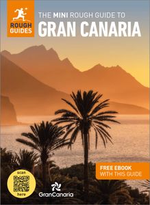
GranCanaria-Summit - Roque Nublo © Visit Gran Canaria
The name means “peak of the snows” and, in the 17th century, pits were dug here to store the snow for the summer. By June these blocks of ice were carried on horseback, wrapped in blankets, to the ice cream shops in the capital, Las Palmas, a journey of around five hours. They were also used at the hospital to control epidemics of yellow fever and cholera.
The peak is the highest point on the island at 1949m, although the summit is covered by a dome-shaped radar installation and radio masts. From the car park, follow the signs to the mirador where you look over the entire south of the island, all the way to Maspalomas. Unlike other lookout points Las Nieves has great views on misty days with Gran Canaria’s peaks seeming to float on a sea of clouds.
La Fortaleza
Near Santa Lucia In the southeast of the island, are the castle-like La Fortaleza rock formations, rising in layers from the fissured valleys below. It was a fortified Guanche settlement and its eastern side has a large of number of natural and artificial caves. These were used as dwellings, food storage and even burial, all linked by a network of paths and tunnels.
It’s recognised as the site of the last stand of the indigenous people against the Castilian conquerors. In 1483 Spanish troops, led by Pedro de Vera, had been besieging the fortress and on the 29th of April the islanders surrendered. It’s said that the leaders, Bentejuí and Tazarte, committed suicide by throwing themselves off the cliff.
The excellent interpretation centre details their tragic history. DNA evidence suggests they were Berbers from North Africa, who arrived around 500BC and lived peacefully until the arrival of the Castilians. Since no boats have been found, some theories suggest they were brought here by the Romans, deported for causing trouble in Africa. The Spaniards found a race of blonde, blue-eyed people and, although many were killed, present day Canarians still have a large percentage of their DNA in their blood.