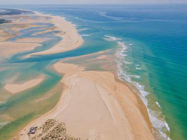
Manteigas
If there’s one town in the Serra da Estrela with a true mountain air it’s MANTEIGAS, 700m up, whose whitewashed houses run along the contour above the Rio Zêzere. The approach from any direction is dramatic: from Sabugueiro and the west the road winds down in convoluted switchbacks; from Belmonte and the east the river scenery is at its most bucolic; while from the south there is the breathtaking descent down the glacial valley of the Rio Zêzere. The latter route brings you into town past the therapeutic spa of Caldas de Manteigas and to the fertile valley bottom of the Zêzere, with Manteigas itself spreading across the steep slope opposite.
There’s no public transport further into the park from town, but with a car you can use Manteigas as a base to visit Torre, the glacial valley and ski fields, and the nearby villages. The town is on two of the official walking trails, but local routes are on the tough side since – south and west at least – you have to climb steep and far to get anywhere. There’s one easy circular walk to the Poço do Inferno, though most other routes are point-to-point, requiring a taxi ride out or back, which can be easily arranged.
A circular walk from Manteigas to the Poço de Inferno
The best circular walk from Manteigas is to the Poço de Inferno waterfall and back, which takes around four hours. Most of the paint-mark trail signs are missing or faded, but it’s a straightforward route with some gorgeous views. The walk starts in the Zêzere valley bottom, from the small bridge and picnic area reached down the steep road behind the turismo in Manteigas.
Cross the bridge, turn left (signposted “Leandres”) and walk for 500m along the road, past the recycling plant, before turning right onto a clear forestry track. Keep straight on, ever upwards through the woods – the first yellow paint sign is on a tree on the right-hand side (6min) and there isn’t another until you reach a ruined white house in a clearing (45min) marked with the words “Matas Nacionais”.
Five minutes' walk after the house is the only turn off the main path – to the left (with paint marks before and after the turn). In another fifteen minutes the path ends at a bend in a tarmac road. Walk uphill (there’s a yellow paint mark almost immediately) and it’s twenty minutes further up the road to the Poço do Inferno, “Hell’s Well”, where the Leandres River pours down the narrow gorge into clear pools overlooked by viewing platforms.
To return, follow the minor road around past the falls, heading back towards Manteigas. This road actually runs steadily down to Caldas de Manteigas, though this would be a long (8km) and unnecessary return to Manteigas itself. Instead, after an hour, at a large water tank by the right-hand side of the road (there’s also a white house, just before a small bridge), turn right down an ancient track – walled in parts – which drops in zigzags through the trees. Ultimately, there are several divergent paths, but as long as you keep going downhill you’ll end up in the group of houses by the Albergaria Berne (another 30min) – from where it’s a steep fifteen-minute climb into Manteigas proper.
Covilhã
Just outside the eastern park boundary, and 44km south of Guarda, the prosperous town of COVILHÃ lies immediately below the highest peaks. It’s busiest on winter weekends, when it’s used as a base for trips to the ski slopes, but it has a life independent of the mountains, which makes it an agreeable place to visit at any time. Virtually every thoroughfare looks out across the plain below or up to the mountain crags – the café in the pretty town gardens has the best view, serenaded by practice sessions in the music conservatory opposite.
A market town since the Middle Ages, Covilhã developed a textile industry in the seventeenth century using wool from the local sheep, which also provide the milk for the renowned queijo da serra (mountain cheese). Later, the woollen industry harnessed water-power from the mountain streams; factories today, down on the plain below town, are powered by hydroelectricity. You can view the enormous vats used in the traditional wool-dyeing processes in the Museo de Lanifícios, located in the former Real Fábrica de Panos (Royal Textile Factory), a short walk downhill from the centre.
Hiking in the Parque Natural
In theory, various hiking trails cut across the Parque Natural da Serra da Estrela, though it’s much harder to walk in the serras than it should be. The park information offices tend not to have English-speaking staff, and it’s rare for the personnel to have any first-hand experience of the trails – often, you’ll simply be pointed to dated or unreliable hiking guides and maps. Moreover, the waymarking (red-and-yellow paintmarks) in the park is unreliable: maintenance doesn’t appear to be a priority and signposting at village trailheads is woeful or non-existent. Well-prepared walkers will need to be self-sufficient in order to complete the longer trails. The best time to walk is from May to October. For the day-hiker, who just wants a taste of the mountains, try the easy circular route from Manteigas to the Poço do Inferno waterfall. Alternatively, you could tackle a short stretch of the lower-level T2 – Linhares to Gouveia, via Folgoshinho, is a good full day’s walk, with facilities in each place – though you’ll need to take a taxi back to your starting point.
Mountain life
In the last decades of the twentieth century, and to a lesser extent more recently, life in the mountains changed almost beyond recognition. Farmers have moved from stone mountain houses to more modern dwellings on the valley floor while many of the former intensively cultivated Zêzere valley terraces have been abandoned in favour of spreading pine plantations. Meanwhile local village production is often now directed towards tourists – delights such as the local queijo da serra, an unctuous mountain cheese, as well as rye bread, fruit preserves, honey from the fertile valleys and blankets made from the wool of grazing upland sheep are all widely available.