Northern Waterford
The northern stretch of the county, along the border with Tipperary, is studded with two modest but pretty mountain ranges, the Comeraghs and the Knockmealdowns, neither of which rises higher than 800 metres. Ballymacarbry, 25km north of Dungarvan on the R672 towards Clonmel, is the best jumping-off point for the Comeraghs, while historic Lismore, 25km west of Dungarvan in the beautiful Blackwater valley, provides easy access to the Knockmealdowns.
The Comeragh Mountains
The best approach to the bleak moorland of the Comeragh Mountains, with its smattering of bogs and heather, is along the Nire valley, which descends westwards from beneath Knockaunapeebra (789m), the range’s highest point, to waterside BALLYMACARBRY.
Lismore
Set amidst verdant countryside on the south side of the River Blackwater is the sleepy town of LISMORE, once a major religious centre. St Carthagh founded a thriving monastery here in 636 that became a great centre of learning and retained both religious and political importance for several centuries, despite periodic raids by the Vikings and later the Anglo-Normans. On the site of its medieval cathedral, wrecked by Edmund Fitzgibbon around 1600, stands the Church of Ireland St Carthagh’s Cathedral, constructed some thirty years later. Much of its appearance derives from remodelling in the early 1800s, including the addition of its tower and spire, and it remains a charming building, set in a tree-lined cobblestone courtyard. Just inside the front door is a lovely stained-glass window by the Pre-Raphaelite Edward Burne-Jones, depicting two virtues: Justice and Humility. A Romanesque arch in the nave might possibly date from the original cathedral and leads to the imposing McGrath tomb which features carvings of the twelve Apostles, the Crucifixion and the martyr St Catherine. Stones set into the back wall, including a particularly stalwart bishop, date from the ninth to eleventh centuries.
Despite the cathedral’s attractions, it is the extravagant and graceful Lismore Castle, its fairytale turrets magnificently set above the River Blackwater, that overshadows the town. The Irish home of the Dukes of Devonshire was designed by Joseph Paxton (also responsible for the Crystal Palace for London’s Great Exhibition of 1851) in the mid-nineteenth century, taking as his starting point the remains of a castle built by Prince John in 1185. Though the bulk of the castle cannot be visited, its extensive gardens present numerous exterior views from different aspects. The gardens consist of woodlands and a host of magnolias, camellias and rhododendrons in season, as well as a yew-tree walk where Edmund Spenser is believed to have written The Faerie Queen. Modern sculptures dot the gardens, and the formerly derelict west wing of the castle has recently been transformed into a gallery that hosts some interesting exhibitions of contemporary art.
The Knockmealdown Mountains
North from Lismore the R668 to Cahir undulates upwards through a lovely river valley, garnished with a mass of woody greenery, before heading into the mountains. To the east, after 10km, rises Knockmealdown itself (793m), whose name translates aptly as “bare brown mountain”, while a little further up the road lies the spectacular viewpoint known as The Vee. At this popular beauty spot, famous for its magnificent display of rhododendrons in late May and early June, the valley sides offer a perfectly chevron-shaped scene of the fields of Tipperary laid out far below, a panoply of greens, browns and yellows. The Tipperary Heritage Way north to Cashel begins here at The Vee, while the seventy-kilometre East Munster Way starts down at Clogheen and heads east from The Vee to Carrick-on-Suir, via the northern foothills of the Knockmealdowns and the Comeraghs.
The lower Suir valley
Rising in the Devilsbit Mountains in the north of Tipperary, the River Suir runs down the length of the county before abruptly turning east in the face of the Knockmealdown Mountains. Along the way it nourishes countless dairy cattle and three significant towns along the southern border with Waterford. While Clonmel, the capital of South Tipp, holds little of interest for visitors, nearby Cahir is a compelling destination, with its mighty castle and the whimsical Swiss Cottage, and Carrick-on-Suir is the site of a rare and well-preserved Elizabethan manor house. Feeding into the Suir to the northwest of Cahir, the luscious Glen of Aherlow is one of the county’s prettiest spots and a fine base for exploring the scenic Galty Mountains. Tucked away on the south side of the range are the fantastic stalactites and stalagmites of Mitchelstown Cave, while the attractive villages of Clogheen and Ardfinnan lie to the east of here in the lee of the Knockmealdowns.
Carrick-on-Suir
In the far southeastern corner of County Tipperary lies the busy market town of CARRICK-ON-SUIR. Its main point of interest is multi-gabled Ormond Castle, Ireland’s only surviving Elizabethan manor house, which is situated at the far eastern end of Castle Street, a continuation of Main Street. Erected in the 1560s by Thomas (“Black Tom”) Butler, tenth Earl of Ormonde, for an (unrealized) visit by his cousin, Elizabeth I, the house contains numerous tributes to her, most notably in the elaborate series of panels in the long gallery. Also displayed is a fine collection of royal charters, including one of 1661 granting the title Duke of Ormonde to Tom’s descendant James.
Cahir
The dominant feature of CAHIR is its castle, one of Ireland’s largest and best preserved, surrounded by the waters of the River Suir at the western entrance to the town. Cahir itself means “fort” in Irish and the town grew up around its thirteenth-century Anglo-Norman stronghold, though much, including the restored outer walls, dates from more recent times. The castle was a power base of the influential Butlers, the Earls of Ormonde, and managed to survive a siege and bombardment by the Earl of Essex in 1599, as well as the invasions of Cromwell and William of Orange. However, after Cromwell’s victory in 1650, the Butlers moved out and the castle fell slowly into disrepair, until it was given new life in the mid-nineteenth century by Richard Butler, the second Earl of Glengall, who impoverished himself in the process. The castle’s entrance leads to the cramped middle ward, overshadowed by the thirteenth-century keep whose chambers feature various displays, including a model of the 1599 siege. To the left of here a gateway, surmounted by defensive viewpoints on each side, leads to the more expansive outer ward. In the inner ward, parts of the larger of the two towers derive from the thirteenth and fifteenth centuries, though the banqueting hall was redesigned by William Tinsley in 1840 for use as the Butlers’ private chapel.
Cahir’s other major attraction is the Swiss Cottage, a twenty-minute riverside stroll south from the town or, if you’re driving, off the Ardfinnan road. Designed by John Nash, architect of the Royal Pavilion at Brighton, this lavish, thatched cottage orné on the castle demesne was constructed in the early 1800s for Richard Butler, the first Earl of Glengall, though his precise reason remains unclear. A contemporary scurrilous theory held that it was to enjoy clandestine liaisons with his mistress, but there is evidence that it was used occasionally as a residence and for entertaining guests thoroughly restored using appropriate timbers and period decor. Entertaining guided tours (with a maximum of twelve people, so you may have a wait during the busy summer months) start from the bovement kitchen and visit the elegant salon, whose interior is decorated with one of the first commercially manufactured Parisian wallpapers, and music room, and ascend via a spiral staircase to the grand master bedroom with its commanding views of the countryside.
The Glen of Aherlow
To Cahir’s northwest lies the lush and resplendent Glen of Aherlow, spreading some 18km from Bansha in the east to Galbally in the west, just across the border in County Limerick. Lying beneath the northern facade of the Galty Mountains, the glen is a marvellous place to drive or cycle around and the scenic circular route is well worth taking. The best vantage point for spectacular views is by the entrance to the Glen of Aherlow Nature Park, 1.5km north of the junction of the R663 and R664. From here on the wooded ridge of Slievenamuck, the glen lies spread out below, light reflecting from the river, and the mountains looming beyond. A one-hour, circular walking trail is laid out through the nature park’s woodlands, while the signposted Ballyhoura Way runs through the Glen to Galbally, on its eighty-kilometre journey from the train station at Limerick Junction via the Ballyhoura Mountains to St John’s Bridge in north Cork.
Book things to do in Limerick
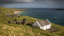
Ardmore
The seaside village of ARDMORE, 20km southwest of Dungarvan, is an enchanting place, rich in religious history and relics, mainly associated with St Declan who established a monastery here some thirty years before St Patrick came to Ireland. There’s a kilometre-long sandy beach at the foot of the village, hemmed in by long, grassy headlands and flanked on its southern side by St Declan’s Stone. According to legend, the saint’s luggage was miraculously transported by this boulder when he travelled from Wales (and thus presumably avoided excess-baggage charges). Heading up the hill towards the southern headland leads past St Declan’s Well, where the saint apparently conducted baptisms in the early fifth century, and where he later retired to a small cell for greater seclusion; on the site of the latter, a now-ruined church was built, probably in the twelfth century. From here there’s a breezy four-kilometre cliff walk, with stunning views, around the headland, which will bring you back to the top of Main Street.
Above the town (and near the end of the cliff walk), on the site of Declan’s original monastery, stands a solid-looking twelfth-century Romanesque cathedral and a willowy, conically capped round tower. The cathedral has lost its roof but its walls are impressively buttressed. Its west wall features an arcade from a previous building, embellished by remarkable carvings of Biblical scenes such as the Judgement of Solomon, while two carved ogham stones – one is the longest in Ireland – can be seen inside. In a corner of the graveyard is St Declan’s Oratory, which possibly dates from the eighth century; the pit in the floor, once covered with a flagstone, is where he was supposedly buried.
Cashel
Though it has some other noteworthy sights, the town of CASHEL – the name derives from the Irish caiseal, meaning “stone fort” – is utterly overshadowed by the stunning Rock of Cashel, an outcrop that rears out of the surrounding fertile plain, the Golden Vale. Surmounted by important ecclesiastical remains, the Rock is a hotspot on the tourist trail, so is best visited in the early morning before the hordes arrive or in the late afternoon when the coaches have departed.
Going on a trip to Ireland? Don't miss our important planning tips.