The Cliffs of Moher
The Cliffs of Moher stretch downwards to the Atlantic for almost 200m. The cliffs take their name from an old promontory fort, Mothar, and extend some 8km from Hag’s Head, west of Liscannor, to a little beyond O’Brien’s Tower, which was constructed by a local altruist in 1835 at their highest point. Access to the cliffs remains unrestricted, but, if you’re travelling by car you’ll be compelled to pay Clare County Council’s extortionate parking charge of €8 for the privilege. Said sum “entitles” visitors (though exactly the same facilities are available if you arrive on bike or foot) to free entry to the controversial €31.5million visitor centre and to the infrequent “cliff edge” guided tours – enquire at the main desk for details.
Tucked away within the hillside, there’s no doubting that the centre is an impressive architectural feat – and its first-floor restaurant does offer panoramic seascapes and a reasonable choice of meals – but to reach it you’ll pass a somewhat tacky range of souvenir shops and find more of the same kind of “Oirish” gifts on sale within. The centre also houses the Atlantic Edge exhibition whose interactive touch-screens, computer games and 3-D film (all to the accompaniment of ethereal “Celtic hush”-style music), do in part provide lucid explanations of the cliffs’ evolution and wildlife, but overall form a ludicrous electronic counterpoint to the actual glories outside.
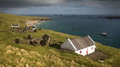
All told, the best bet is to head straight past the centre and to the steps which curve upwards towards the cliff-top. Then you can opt for turning south towards Hag’s Head or in the opposite direction to O’Brien’s Tower where the latter’s viewing platform offers the best sight of the wave-battered cliffs below, enhanced by the resonant roar of the Atlantic waves pummelling the rocks at shore level. The optimum time to visit is around sunset when the heights and sea are spot-lit by the rays of the evening sun. Alternatively, you can gain a different perspective of their prodigious stature from one of the regular boat-trips run from the pier at Doolin by the companies operating ferries to the Aran Islands.
Doolin
In the 1960s the then tiny village of DOOLIN, 7km north of the Cliffs of Moher, developed a reputation for its traditional music, largely thanks to the reputation of a bachelor farmer Micho Russell, a singer, flute and whistle player. Appreciation for his very natural and rhythmic playing resulted in TV and radio appearances and an international touring career. Attracted by his music, a trickle of enthusiasts began to visit Doolin’s pubs to hear the playing of Micho and his two brothers Packie and Gussie, all sadly departed. Today, Doolin is awash with tourists virtually throughout the year, cramming into its pubs (O’Connor’s in Fisher Street on the way to the harbour, Fitzpatrick’s Bar in the Hotel Doolin – and McGann’s and McDermott’s at the northern end) enticed by the village’s renown. Unfortunately, most of the music churned out nightly is not the “pure drop”, but either neatly adjusted to suit popular tastes or simply amplified garbage, and in truth there are many other and better places to hear Clare’s often fabulous traditional music.
The village itself is not especially attractive either, sprawling across mainly flat land towards the sea and cluttered by an incoherently planned jumble of modern houses. Yet, for all its faults, you will occasionally strike lucky with a session and there’s no doubting that the place does possess a certain charm.
Limerick city
All manner of routes – by road, rail and even air, to nearby Shannon Airport – lead to Limerick, the Republic’s third city, which is gradually overcoming its reputation as both a dour industrial centre and a focus for internecine gangland feuds, and has far more going for it than such images might suggest. Indeed, over the last five years, the city has been rejuvenated, thanks to some sensitive and imaginative development projects, especially alongside the river. You could easily spend half a day poking around the beautiful Hunt Museum, a rich and diverse collection of art and antiquities in the Georgian Custom House. The Anglo-Norman castle and cathedral are also both impressive, and it’s well worth checking out the year-round roster of vibrant festivals. As well as substantial renovation of the Shannon quays, regeneration efforts have included the extensive campus at Plassey, 3km southeast, which is also the site of the National Technological Park – the three colleges here, the university, Institute of Technology and College of Education, certainly help to enliven the city’s cultural life and nightlife.
Some history
The Vikings sailed up the Shannon in about 922 and established a settlement here on a river island, formed by a narrow branch off the main flow that is today called the Abbey River. This port at the lowest fording point of the river was coveted by the Anglo-Normans, who in 1197, decisively seized, and set about fortifying, the town. This involved building high city walls around what became Englishtown, to keep out the local Irish, who retreated to a ghetto to the southeast across the Abbey River – Irishtown.
In the late seventeenth century, the final bloody scenes of the War of the Kings were played out here. After their defeat at the Boyne in 1690, the Jacobite forces in Limerick castle, under the Earl of Tyrconnell and local hero Patrick Sarsfield, refused to surrender. Though beset by a vastly superior force, Sarsfield managed to raise the siege by creeping out at night with five hundred men and destroying the Williamite supply train. When William’s army came back in 1691, however, the medieval walls of the castle were unable to withstand the artillery bombardment. Tyrconnell having died of a stroke, Sarsfield surrendered on October 3, 1691, on supposedly honourable terms, according to the Treaty of Limerick. The Jacobites – some twelve thousand in all, later known as the “Wild Geese” – were permitted to go to France, in whose cause Sarsfield fought and later died. The treaty also promised Catholics the comparative religious toleration they had enjoyed under Charles II, but the English went back on the deal, and between 1692 and 1704 the Irish Parliament passed the harshly anti-Catholic penal laws.
The eighteenth century proved to be far more prosperous for Limerick, which in the 1750s received a grant of £17,000 from the Irish Parliament towards a major redevelopment. Completed in 1840 and named after the local MP, Newtown Pery comprised a grid of broad Georgian terraced streets, built well to the south of the cramped, fetid medieval city. In the early twentieth century, however, Limerick suffered greatly during the nationalist struggles, which, in 1919, gave rise to a radical movement that’s unique in Irish history. In protest against British military action during the War of Independence, the local Trades Council called a general strike and proclaimed the Limerick Soviet. With help from the IRA, they took over the city, controlling food distribution, setting up a citizens’ police force and even printing their own money. It lasted only a few weeks, however, collapsing under pressure from the Catholic bishop. In 1921, both Limerick’s mayor, George Clancy, and the former mayor, Mícheál O’Callaghan, were murdered by the Royal Irish Constabulary. One of the effects of the Troubles was that the rich were persuaded to move out of the city: many of their Georgian houses in Newtown Pery became tenements and remain dilapidated to this day, while recent investment has concentrated on developing an industrial base around the city and on renovating the quaysides.
The limerick
Limericks became common in Britain in the nineteenth century, popularized by Edward Lear, but their origin is shrouded in the mists of time. One possible theory is that the form derives from the satirical rhymes of the Maigue Poets (named after the river that runs through Adare), who were translated from Irish into English in the mid-nineteenth century.