Lögurinn
Stretching 30km southwest from Egilsstaðir, Lögurinn is a long, narrow lake on the mid-reaches of the Largarfljót river – which itself originates up in the highlands at Vatnajökull’s northeastern edge, near Snæfell. Unusually for Iceland, the eastern shore is fairly well wooded; there’s also saga lore and medieval remains to take in, along with an impressive waterfall. Deep and green, the lake itself is said to be home to the Lagarfljótsormur, a monster of the Scottish Loch Ness and Swedish Storsjön clans. First recorded in 1345, it’s proved so elusive since, that nobody is even very sure what it looks like.
Lögurinn and its sights take an easy few hours to circuit in your own vehicle (there’s no public transport); the two bridges across are both down towards the southern end of the lake. You’ll also need to pass by en route to Kárahnjúkar and Snæfell, as the road runs off Lögurinn’s southwestern shore.
Hrafnkel’s Saga
Lögurinn and the lands to the west form the stage for Hrafnkel’s Saga, a short but strikingly ambiguous story set before the country converted to Christianity in 1000 AD. It tells of the landowner Hrafnkel, a hard-working but headstrong devotee of the pagan fertility god Freyr, who settled Hrafnkelsdalur, a highland valley 35km west of Lögurinn. Here he built the farm Aðalból, and dedicated a shrine and half his livestock to the god – including his favourite stallion, the dark-maned Freyfaxi, which he forbade anyone but himself to ride on pain of death.
Inevitably, somebody did. Hrafnkel’s shepherd, Einar, borrowed Freyfaxi to track down some errant ewes and, caught in the act, was duly felled by Hrafnkel’s axe. Looking for legal help, Einar’s father enlisted his sharp-witted nephew Sámur, who took the case to court at the next Alþing at Þingvellir. But nobody wanted to support a dispute against such a dangerous character as Hrafnkel, until a large party of men from the suitably distant West Fjords offered their services. As Sámur presented his case, his allies crowded around the gathering and Hrafnkel, unable to get close enough to mount a defence, was outlawed.
Disgusted, Hrafnkel returned home where he ignored his sentence, but Sámur and the West Fjorders descended on his homestead early one morning, dragged him out of bed, and told him to choose between death or giving his property to Sámur. He took the latter option, leaving Aðalból and moving east over the Lagarfljót to Hrafnkelsstaðir, a dilapidated farm that he was forced to buy on credit.
Over the next six years Hrafnkel built up his new property and, his former arrogance deflated, became a respected figure. Meanwhile, Sámur’s brother Eyvind returned from a long overseas trip and decided to visit Sámur at Aðalból. Stupidly riding past Hrafnkelsstaðir, Eyvind was cut down by Hrafnkel and his men, who then launched a raid on Aðalból, capturing Sámur and giving him the same choices that Sámur had given him: to die or hand over the farm. Like Hrafnkel, Sámur chose to live and retired unhappily to his former estate. For his part, Hrafnkel regained his power and influence and stayed at Aðalból until his death.
The East Fjords
The East Fjords are a rewarding stretch of coastline on any Iceland trip, covering about 120 km of eastern Iceland between Borgarfjörður Eystri in the north and Berufjörður in the south. None of the fjords is especially large, but many cradle small villages that still revolve around fishing.
In summer the scenery is at its most vivid, with villages set between the flat blue sea and steep, steel grey mountains, snowy peaks above and green, flowered slopes below.
Beyond the views and the puffins at Borgarfjörður Eystri, highlights include the black sand beach at the fishing village of Breiddalsvík and Hallormsstaðaskógur, Iceland’s largest forest, on the eastern side of Lake Lagarfljót.
Papey Island
Papey Island, also known as Friars Island, is one of east Iceland's secrets that pleases travellers when visiting the East Fjords. The now uninhabited island was home to Gaelic monks in the 10th century before residents moved to the mainland in 1966 leaving behind tranquil solitude, sparkling waters and remnants that are worth visiting such as the lighthouse, church and weather station. Boat trips leave from nearby Djúpivogur in the Summer making a nice day-trip.
Seyðisfjörður
One of the East Fjords most popular towns, Seyðisfjörður, known for its Norwegian-style wooden houses and all-around Scandinavian influences, is a haven for waterfalls, snow-capped mountains, and hiking trails. Other activities include scuba diving, sea angling, and horse-back riding.
Borgarfjörður Eystri
Borgarfjörður church
Isolated in a field on the edge of town, Borgarfjörður’s church is a standard nineteenth-century wood and corrugated iron affair, though the unusual altarpiece is a sunset-hued affair painted in 1914 by Jóhannes Kjarval. Typically incorporating a local landscape into the work, Kjarval depicted the Sermon on the Mount delivered atop of Álfaborg, the rocky hillock behind the church; Álfaborg means “elf-town” and, according to folklore, is home to Iceland’s fairy queen.
Hikes from Borgarfjörður Eystri
Borgarfjörður Eystri is quite a hiking haven, with a good number of marked trails heading up the valley from town. However, the possibility of dense fogs and atrocious weather with heavy snow on higher ground make it essential to ensure you’re properly equipped, and to seek local advice before setting out. To book hut space along the way, contact the local hiking organization.
Prominent behind Borgarfjörður Eystri, Dyrfjöll, the “Door Mountain”, gets its name from the gap in its sharp-peaked, 1136m-high basalt crest. This is another abode of local spirits, mischievous imps that emerge around Christmas to tie cows’ tails together. A round-trip from town would be a major hike, though you could arrange a lift up to the top of the pass at Geldingafjall on the Egilsstaðir road, from where there’s a marked track around the upper reaches of the mountain, and then down to the end of the valley south of town – a full day’s walk.
A good introduction to the area is to hike 4km or so west to the next bay of Brúnavík, whose steeply sloping valley was farmed until being abandoned in the 1940s. This is a story typical of the northern East Fjords; as the herring industry fizzled out after World War II, and roads and services began to bypass the region, farms founded in Viking times were given up as people moved on. There’s a small shelter shed here today, and a further rough trail over loose-sided fells to Breiðavík, where there’s a hiking hut and campsite with water and toilets and a 7km jeep track northwest back to town – the round-trip via Brúnavík and Breiðavík takes about fourteen hours.
Norðfjörður hikes
Several hiking trails begin at Neskaupstaður’s campsite. The easiest follows the coast for 1.5km to Páskahellir – Easter Cave – from where it’s said you can see the sun dancing on Easter morning. A much tougher proposition is the full-day marked trail north over the mountains into Mjóifjörður; or the 10km return hike up along the ridgetop to Flesjartangi, right at the mouth of Mjóifjörður.
Southeast Iceland
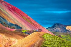
South of Djúpivogur, the fjords recede into the background and you enter the altogether different world of southeastern Iceland, a coastal band between the East Fjords and Vík which is dominated by Europe’s largest ice cap, Vatnajökull. Covering eight thousand square kilometres, almost 150km wide and up to 1km thick, Vatnajökull’s vast size gradually sinks in as it floats inland for hour after hour as you drive past, its glacier tongues flowing in slow motion from the heights to sea level, grinding out a black gravelly coastline as they go. Vatnajökull National Park covers 12,000 square kilometres of this unspoiled wilderness – an extraordinary eleven percent of Iceland’s total landmass – accessible by hiking, four-wheel-driving or even by snowmobile. Flying is perhaps the only way to absorb Vatnajökull’s full immensity: glaring ice sheets shadowed in lilac; pale blue tarns; and grey, needle-sharp nunataks – mountain peaks – poking through the ice.
Given Vatnajökull’s proximity, Iceland’s “mini ice-age” between 1200 and 1900 hit the southeast especially hard – not to mention the devastating jökulhlaups that flood out from beneath Vatnajökull’s icy skirt from time to time – and it remains a thinly settled area, even though all glaciers here are retreating as the climate warms once more. Vatnajökull’s eastern flank is accessed at Lónsöræfi, a private reserve managed by Stafafell farm, close to the regional hub of Höfn. There’s the stunning sight of icebergs floating on the lagoon at Jökulsárlón; and the ice cap’s southern glaciers and adjacent heaths to explore at Skaftafell National Park and Skeiðarársandur, a huge glacier-induced wilderness between Vatnajökull and the sea. Moving away from Vatnajökull, Kirkjubæjarklaustur is the southeast’s second settlement, near where lava fields and craters at Lakagígar stand testament to one of Iceland’s most violent volcanic events. Note that almost the only shops and banks in the entire region are at Höfn and Kirkjubæjarklaustur, which are 200km apart.
Grímsvötn and jökulhlaups
Jökulhlaups are massive, volcanically induced flash floods that regularly burst out from under Vatnajökull, carrying untold tonnes of debris and water before them. One cause of these floods is Grímsvötn, a smouldering volcano buried 400m under the ice cap inland from Skeiðarársandur. The volcano’s last major eruption was in 2011, but the biggest event of recent times occurred in October 1996 after a 6km-long vent opened up under the ice. For ten days the volcano blew steam, ash and smoke 6km into the sky; then, at 8am on November 5, the melted ice suddenly drained out underneath Skeiðarárjökull, sending three billion litres of water spewing across Skeiðarársandur in a 5m-high wave, sweeping away 7km of road and – despite design precautions – demolishing several bridges. Fourteen hours later the flood rate was peaking at 45,000 cubic metres per second, and when the waters subsided a day later, the sandur was dotted with house-sized chunks of ice ripped off the front of Skeiðarárjökull. Aside from the barren scenery, there’s very little evidence for any of this today – the ice has long gone and the bridges are repaired – though look for the twisted remains of Skeiðarárbrú, one of the Ringroad bridges destroyed by the event, which are on display by the roadside west of Skaftafell.
Hiking through Lónsöræfi
A dozen or so demanding hiking trails run north through Lónsöræfi and right up to Snæfell. This is a remote area: don’t hike alone, and bring everything you’ll need with you – warm clothing, food, water and a tent – as weather or navigation errors can see even one-day walks accidentally extended. You’ll also want Mál og menning’s Lónsöræfi 1:100,000 map. Note that the reserve’s waterways are all glacier-fed, making for unpredictable flow rates in summer. Hiking huts along the way – which you need to book in advance – are operated by Ferðafélag Austur-Skaftfellinga and Vatnajökull National Park.
Grákinn
A short, easy hike (5hr return) follows erratic marker pegs uphill behind Stafafell Farm hostel onto the moor, above but away from the east side of the Jökulsá í Lóni river. It’s slightly boggy heathland, with spongy cushions of moss, low birch thickets and hummocks of gravel; there’s a tight grouping of fells looming to the northeast, while the west is more open. Following a general northwest bearing, after a couple of hours you’ll find yourself above the shattered, orange and grey rhyolite sides of the Grákinn valley; scramble west down the scree and then crisscross the stream to where the valley appears to dead-end in a wall of dark cliffs. Push through a short canyon and exit to the Jökulsá í Lóni, which you follow southeast downstream along a dull jeep track to the highway and the farm.
Lónsöræfi to Snæfell
The hike from Stafafell to Snæfell takes at least four days. Contact the farm to arrange a lift in a vehicle across the Jökulsá í Lóni at the start of the hike; at the other end there is no public transport from Snæfell to Egilsstaðir, so you’ll need to risk finding somebody to hitch with, or contact Tanni Travel, who can arrange pickups. There’s one short glacier traverse along the way, requiring a little experience; otherwise you just need to be fit.
Once over the multi-streamed Jökulsá í Lóni, there’s a hut and campsite at Eskifell. From here, you follow an ever-tightening gorge due north to another hut and campsite at Illikambur, around 25km from Stafafell, from where there are several day-walks along side-gorges and up nearby peaks, including a route west up to Rauðhamar for views down onto Öxarfellsjökull, Vatnajökull’s easternmost extension.
Back on the main track, around 10km north of Illikambur is Víðidalur, an attractive valley with campsite to the south and lakeside hut 2km to the northwest at Kollumúlvatn, where there are further glacial views and trails northwest to a collection of wind-scoured outcrops known as Tröllakrókar, “troll spires”. The next 17km follows Vatnajökull’s northeastern edge to the Geldingafell hut; from here, the final stage to Snæfell is a lengthy 35km (avoiding unfordable rivers), first westwards over the tip of Eyjabakkajökull, then bearing north at Litla-Snæfell to the hut on Snæfell’s west side.
Kirkjubæjarklaustur
Kirkjubæjarklaustur – a tongue-twisting name that even locals often abbreviate to “Klaustur” – is only a single street, Klausturvegur, which stretches 500m west from a highway roundabout. However, as it’s the sole settlement of any size in the 300km between Höfn and Vík, it’s almost inevitable that you’ll stop here. The village sits at the foot of an escarpment on the Skaftá, whose circuitous path originates on the western side of Vatnajökull, and is flanked by lavafields from eruptions by Lakagígar in 1783, centred some 75km to the northwest.
The church
Kirkjubæjarklaustur’s modern church is sided in granite slabs and has a facade resembling a ski lodge. A Benedictine convent was established here in 1186, though two of its nuns had the misfortune to be burned at the stake for heresy. But it was during the Lakagígar eruptions that the church here achieved national fame: as lava flows edged into the town, the pastor, Jón Steingrímsson, delivered what became known as the “Fire Sermon”, and the lava halted. It’s possible to climb the escarpment behind the church by means of a chain, and from the top there’s a fine view of the diverted flow, and also of Landbrot, a collection of a thousand-odd pseudocraters formed during another eruption in 950.
Lakagígar
Lón
Lón is a glacial river valley whose 30km-wide estuary is framed by Eystrahorn and Vestrahorn, two prominent spikes of granite to the east and west. The central Jökulsá i Lóni is a typical glacial flow, its broad gravel bed crisscrossed by intertwined streams that are crystal clear and shallow in winter but flow murky and fast with increased snowmelt in summer. A sandbar across the mouth of the bay has silted the estuary up into lagoons – lón in Icelandic – with good trout fishing, thousands of whooper swans nesting on the eastern side, and reindeer herds descending from the upper fells in winter.
Lónsöræfi
The highlands inland from Stafafell are known as Lónsöræfi, the Wilderness of Lón, an unspoiled area of streams, moor and fractured rhyolite hills, capped by Vatnajökull’s eastern edge (though this is invisible from the main road). Now incorporated into a private reserve accessed through Stafafell farm, Lónsöræfi is beautiful hiking country, where you could spend anything from a few hours to several days on remote tracks – or even hike north through to Snæfell, near Egilsstaðir.
Stafafell
Halfway across Lón and just east of the river, a short road off the Ringroad heads inland to Stafafell, comprising a couple of farm buildings, a hostel and an unassuming church, surrounded by birch trees. The site was consecrated a generation after the tenth-century Norwegian missionary Þangbrand – armed with a sword, and a crucifix instead of a shield – killed Stafafell’s pagan owner in a duel and went on to spread the Christian message across Iceland, surviving attacks by sorcery and a berserker in the process. His activities divided the country and finally forced the Alþing to restore unity by accepting Christianity as the national religion in 1000.
Top image: Mountain Stapafell in the background at Arnarstapi Village in summer sunny day in Iceland © takepicsforfun/Shutterstock