Brief history of the Peloponnese
Anciently known as the Moreas, from the resemblance of its outline to the leaf of a mulberry tree (mouriá), the Peloponnese was home to some of the most powerful rulers in ancient Greece. During the Mycenaean period (around 2000–1100 BC), the peninsula hosted the semi-legendary kingdoms of Agamemnon at Mycenae, Nestor at Pýlos and Menelaus at Sparta. In the Dorian and Classical eras, the region’s principal city-state was Sparta, which, with its allies, brought down Athens in the ruinous Peloponnesian War. Under Roman rule, Corinth was the capital of the southern Greek province.
From the decline of the Roman Empire to the Ottoman conquest, the Peloponnese pursued a more complex, individual course from the rest of Greece. A succession of occupations and conquests, with attendant outposts and castles, left an extraordinary legacy of medieval remains. It retained a nominally Roman civilization well after colonial rule had dissipated, with Corinth at the fore until it was destroyed by two major earthquakes in the fourth and sixth centuries.
The Byzantines established their courts, castles and towns from the ninth century onward; their control, however, was only partial. The Venetians dominated the coast, founding trading ports at Monemvasiá, Pýlos and Koróni, which endured, for the most part, into the fifteenth century. The Franks, fresh from the sacking of Constantinople in the Fourth Crusade, arrived in 1204 and swiftly conquered large tracts of the peninsula, dividing it into feudal baronies under a prince of the Moreas.
Towards the mid-thirteenth century, there was a remarkable Byzantine renaissance, which spread from the court at Mystra to reassert control over the peninsula. A last flicker of “Greek” rule, it was eventually extinguished by the Turkish conquest between 1458 and 1460, and was to lie dormant, save for sporadic rebellions in the perennially intransigent Máni, until the nineteenth-century Greek War of Independence.
The nineteenth and twentieth centuries
The Peloponnese played a major part in the revolt against the Turks, with local heroes Theodhoros Kolokotronis and Petros Mavromihalis becoming important military leaders. At Pýlos, the international but accidental naval battle at Navarino Bay in 1827 decided the war, and the first Greek parliament was convened at Náfplio. After independence, however, power swiftly drained away from the Peloponnese to Athens, where it was to stay. The peninsula became disaffected, highlighted by the assassination of Kapodhistrías, the first Greek president, by Maniots in Náfplio.
Throughout the nineteenth and early twentieth centuries, the region developed important ports at Pátra, Kórinthos and Kalamáta, but its interior reverted to backwater status, starting a population decline that has continued up to the present. It was little disturbed until World War II, during which the area saw some of the worst German atrocities; there was much brave resistance in the mountains, but also some of the most shameful collaboration. The subsequent civil war left many of the towns polarized and physically in ruins; in its wake there was substantial emigration from both towns and countryside, to North America and Australia in particular. Earthquakes still cause considerable disruption, as at Kórinthos in 1981, Kalamáta in 1986, and Éyio in 1995.
Today, the southern Peloponnese has a reputation for being one of the most traditional and politically conservative regions of Greece. The people are held in rather poor regard by other Greeks, though to outsiders they seem unfailingly hospitable.
The Argolid
The region that you enter to the south and southeast of Corinth was known as the Argolid, or Argolídha in modern Greek, after the city of Árgos, which held sway here in Classical times. The greatest concentration of ancient sites in Greece is found in this compact peninsula, making it a natural focus for an ancient Greece tour. Its western boundary is delineated by the main road south from Kórinthos, and within less than an hour’s drive of each other are Agamemnon’s fortress at Mycenae, the great theatre of Epidaurus, and lesser sites at Tiryns and Árgos.
In peak season you may want to see the sites early or late in the day to realize their magic. When ruin-hopping palls, there are the resort-town pleasures of elegant Náfplio, and a handful of beach resorts.
Mycenae
Tucked into a fold of the hills just east of the road from Kórinthos to Árgos, Agamemnon’s citadel at MYCENAE, or Mykínes, fits the legend better than any other place in Greece. It was uncovered in 1874 by the German archaeologist Heinrich Schliemann, who also excavated the site of Troy, impelled by his single-minded belief that there was a factual basis to Homer’s epics. Schliemann’s finds of brilliantly crafted gold and sophisticated tomb architecture bore out the accuracy of Homer’s epithets of “well-built Mycenae, rich in gold”. With the sound of bells drifting down from goats grazing on the hillsides, a stroll around the ramparts is still evocative of earlier times and gives real depth to a Greek ancient sites trip.
Brief history of Mycenae
The Mycenae-Árgos region is one of the longest occupied in Greece, with evidence of Neolithic settlements from around 3000 BC. But it is to the period from around 1550 to 1200 BC that the citadel of Mycenae and its associated drama belong. This period is known as Mycenaean, a term that covers not just the Mycenae region but a whole Bronze Age civilization that flourished in southern Greece at the time, referred to in Homer’s epics.
The archeological remains of Mycenae fit remarkably easily with the tales (see Mycenaean murders), at least if it is taken as a poetic rendering of dynastic struggles, or, as most scholars now believe it to be, a merging of stories from various periods. The buildings unearthed by Schliemann show signs of occupation from around 1950 BC, as well as two periods of intense disruption, around 1200 BC and again in 1100 BC – at which stage the town, though still prosperous, was abandoned.
No coherent explanation has been put forward for these events, but it seems that war among the rival kingdoms was a major factor in the Mycenaean decline. These struggles appear to have escalated as the civilization developed in the thirteenth century BC: excavations at Troy revealed the sacking of that city, quite possibly by forces led by a king from Mycenae, in 1240 BC. The Mycenae citadel seems to have been replanned, and heavily fortified, during this period.
The Citadel
The Citadel of Mycenae is entered through the famous Lion Gate, whose huge sloping gateposts bolster walls dubbed “Cyclopean” by later Greeks, in bewildered attribution to the only beings deemed capable of their construction. Above them a graceful carved relief stands out in confident assertion: Mycenae at its height led a confederation of Argolid towns (Tiryns, Árgos, Assine, Hermione – present-day Ermióni), dominated the Peloponnese and exerted influence throughout the Aegean. The motif of a pillar supported by two muscular lions was probably the symbol of the Mycenaean royal house, for a seal found on the site bears a similar device.
Royal graves
Inside the walls to the right is Grave Circle A, the royal cemetery excavated by Schliemann, who believed it contained the bodies of Agamemnon and his followers, murdered on their triumphant return from Troy. Opening one of the graves, he found a tightly fitting and magnificent gold mask that had somehow preserved the flesh of a Mycenaean noble; “I have gazed upon the face of Agamemnon,” he exclaimed in an excited cable to the king of Greece. For a time it seemed that this provided irrefutable evidence of the truth of Homer’s tale. In fact, the burials date from about three centuries before the Trojan War, though given Homer’s possible combining of several earlier sagas, there’s no reason why they should not have been connected with a Mycenaean king Agamemnon. They were certainly royal graves, for the finds (now in the National Archeological Museum in Athens) are among the richest that archeology has yet unearthed.
Royal palace
Schliemann took the extensive South House, beyond the grave circle, to be the Palace of Agamemnon. However, a building much grander and more likely to be the Royal Palace was later discovered near the summit of the acropolis. Rebuilt in the thirteenth century BC, this is an impressively elaborate and evocative building complex; although the ruins are only at ground level, the different rooms are easily discernible. Like all Mycenaean palaces, it is centred around a great court: on the south side, a staircase would have led via an anteroom to the big rectangular throne room; on the east, a double porch gave access to the megaron, the grand reception hall with its traditional circular hearth. The small rooms to the north are believed to have been royal apartments, and in one of them the remains of a red stuccoed bath have led to its fanciful identification as the scene of Agamemnon’s murder.
The secret cistern and merchant houses
A salutary reminder of the nature of life in Mycenaean times is the secret cistern at the eastern end of the ramparts, created around 1225 BC. Whether it was designed to enable the citadel’s occupants to withstand siege from outsiders, rival Mycenaeans or even an increasingly alienated peasantry is not known. Steps lead down to a deep underground spring; it’s still possible to descend the whole way, though you’ll need to have a torch and be sure-footed, since there’s a drop to the water at the final turn of the twisting passageways. Nearby is the House of Columns, a large and stately building with the base of a stairway that once led to an upper storey.
Only the ruling Mycenaean elite could live within the citadel itself. Hence the main part of town lay outside the walls and, in fact, extensive remains of merchants’ houses have been uncovered near to the road. Their contents included inscribed tablets (in Linear B, an early form of Greek) which detailed the spices used to scent oils, suggesting that the early Mycenaeans may have dabbled in the perfume trade. The discovery of the tablets has also shown that, here at least, writing was not limited to government scribes working in the royal palaces, as had previously been thought, and that around the citadel there may have been a commercial city of some size and wealth.
Tholos tombs
Alongside the merchants’ houses are the remains of Grave Circle B, from around 1650 BC and possibly of an earlier, rival dynasty to those kings buried in Grave Circle A, and two tholos (circular chamber-type) tombs, identified by Schliemann as the tombs of “Aegisthus” and “Klytemnestra”. The former, closer to the Lion Gate, dates from around 1500 BC and has now collapsed, so is roped off; the latter dates from some two centuries later – thus corresponding with the Trojan timescale – and can still be entered.
The Treasury of Atreus
Four hundred metres down the road from the Citadel site is another, far more startling, tholos, known as the Treasury of Atreus or – the currently preferred official name – “Tomb of Agamemnon”. This was certainly a royal burial vault at a late stage in Mycenae’s history, contemporary with the “Tomb of Klytemnestra”, so the attribution to Agamemnon is as good as any – if the king were indeed the historic leader of the Trojan expedition. Whoever it belonged to, this beehive-like structure, built without the use of mortar, is an impressive monument to Mycenaean building skills. Entering the tomb along a majestic 15m corridor, you arrive at the chamber doorway, above which is a great lintel formed by two immense slabs of stone – one of which, a staggering 9m long, is estimated to weigh 118 tonnes.
Mycenaean murders
According to legend, the city of Mycenae was founded by Perseus, the slayer of Medusa the Gorgon, before it fell into the bloodied hands of the House of Atreus. Atreus, in an act of vengeance for his wife’s seduction by his brother Thyestes, murdered Thyestes’ sons, and fed them to their father. Not surprisingly, this incurred the wrath of the gods: Thyestes’ daughter, Pelopia, subsequently bore her father a son, Aegisthus, who later murdered Atreus and restored Thyestes to the throne.
The next generation saw the gods’ curse fall upon Atreus’ son Agamemnon. On his return to Mycenae after commanding the Greek forces in the Trojan War – a role in which he had earlier consented to the sacrifice of his own daughter, Iphigeneia – he was killed in his bath by his wife Klytemnestra and her lover, Aegisthus, who had also killed his father. The tragic cycle was completed by Agamemnon’s son, Orestes, who, egged on by his sister Elektra, took revenge by murdering his mother, Klytemnestra, and was pursued by the Furies until Athena finally lifted the curse on the dynasty.
The southeastern peninsula: Vátika
The isolated southeasternmost “finger” of the Peloponnese is known as Vátika. It comprises a dramatic and underpopulated landscape of harsh mountains and poor, dry, rocky soil. The highlight here is the extraordinarily preserved Byzantine enclave of Monemvasiá – an essential visit for any tour of the southern Peloponnese. The rest of this slim peninsula is little visited by tourists, except for the area around Neápoli, the most southerly town in mainland Greece, which offers access to the islet of Elafónissos, just offshore, and to the larger island of Kýthira, lying on the way to Crete.
Monemvasiá
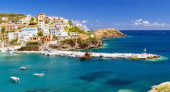
MONEMVASIÁ, standing impregnable on a great island-like irruption of rock, was the medieval seaport and commercial centre of the Byzantine Peloponnese. Its modern mainland service town is called Yéfira, from which a 1km causeway takes visitors out to the medieval site. Divided into the inhabited lower town and the ruined upper town, it’s a fascinating mix of atmospheric heritage, careful restoration and sympathetic redevelopment, giving a Peloponnese odyssey tour a powerful sense of medieval drama.
Fortified on all approaches, it was invariably the last outpost of the Peloponnese to fall to invaders, and was only ever taken through siege. Even today, it differs deeply in character from the nearby mainland.
Brief history of Monemvasiá
Founded by the Byzantines in the sixth century, Monemvasiá soon became an important port. It later served as the chief commercial port of the Despotate of Mystra and was for all practical purposes the Greek Byzantine capital, with a population of almost 60,000. Like Mystra, Monemvasiá had something of a golden age in the thirteenth century, when it was populated by a number of noble Byzantine families and reaped considerable wealth from estates inland, wine production (the Mediera-like Malvasia) and from their own roving corsairs who preyed on shipping heading for the East.
When the rest of the Moreas fell to the Turks in 1460, Monemvasiá was able to seal itself off, placing itself first under the control of the papacy, later under the Venetians. Only in 1540 did the Turks gain control, the Venetians having abandoned their garrison after the defeat of their navy at Préveza.
Monemvasiá was again thrust to the fore during the War of Independence, when, in July 1821, after a terrible siege and wholesale massacre of the Turkish inhabitants, it became the first of the major Turkish fortresses to fall. After the war, there was no longer any need for such strongholds and, with shipping moving to the Corinth Canal, the town drifted into a village existence, its buildings allowed to fall into ruin. By the time of World War II only eighty families remained. Today just a handful of people are in permanent residence, but much restoration work has been done to the houses, walls and many of the churches.
The rock: medieval Monemvasiá
From mainland Yéfira nothing can be seen of the medieval town itself, which is built purely on the seaward face of the rock. Nor is anything revealed as you cross the causeway to the Kástro, as locals call it; but the 1km-long entrance road, used for parking, finally deadends at castellated walls. Once through the fortified entrance gate, narrow and tactically z-shaped, everything looms into view: in the lower town, clustered houses with tiled roofs and walled gardens, narrow stone streets, and distinctively Byzantine churches. High above, the extensive castle walls protect the upper town on the summit.
The lower town
The lower town once numbered forty churches and over eight hundred homes, an incredible mass of building, which explains the confusing labyrinth of alleys. A single main street – up and slightly to the left from the gateway – is lined with cafés, tavernas and souvenir shops.
At the end of this street is the lower town’s main square, a beautiful public space, with a cannon and a well in its centre, and the setting for the great, vaulted cathedral, built by the Byzantine emperor Andronikos II Komnenos when he made Monemvasiá a see in 1293. The largest medieval church in southern Greece, it is dedicated to Christ in Chains, Elkómenos Khristós. Across the square is the domed church of Áyios Pétros, originally a sixteenth-century mosque, which was reconverted by the Turks back into a mosque in the eighteenth century and now houses a small museum of local finds (officially Tues–Sun 8.30am–3pm in winter, till 8pm in summer; free). Unusually for Ottoman Greece, the Christian cathedral was allowed to function during the occupation, and did so beside this mosque.
Access by water is as limited as by land. In peaceful times, the town was supplied from the tiny external harbour, Kourkoúla, below the road as you approach the entrance gateway. While in town, down towards the sea, the Portello is a small gate in the sea wall; you can swim off the rocks here.
The upper town
The climb to the upper town is highly worthwhile – not least for the solitude, since most day-trippers stay down below – and it is less strenuous than it initially looks (20–30min depending on fitness). To get the most from the vast site, it’s a good idea to bring some food and drink (from Yéfira, since Monemvasiá has no proper supermarket), so you can explore at leisure. There are sheer drops from the rockface, and unfenced cisterns, so descend before dusk.
The fortifications, like those of the lower town, are substantially intact, with even the entrance gate retaining its iron slats. Within, the site is a ruin, unrestored and deserted though many structures are still recognizable, and there are information boards. The only building that is relatively complete, even though its outbuildings have long since crumbled to foundations, is the beautiful thirteenth-century Ayía Sofía (usually locked), a short distance up from the gateway. It was founded on the northern rim of the rock as a monastery by Andronikos II.
Beyond the church extend acres of ruins; in medieval times the population here was much greater than that of the lower town. Among the remains are the stumpy bases of Byzantine houses and public buildings, and, perhaps most striking, vast cisterns to ensure a water supply in time of siege. Its weak point was its food supply, which had to be entirely imported from the mainland. In the last siege, by Mavromihalis’s Maniot army in the War of Independence, the Turks were reduced to eating rats and, so the propagandists claimed, Greek children.
Yéfira
YÉFIRA is little more than a straggle of hotels, rooms and restaurants serving the rock’s tourist trade, with a pebble beach; though for a beach day-trip, it’s best to head 3–4km north along the coast to Porí beach, or via a separate road to the very clean, northern, Kastráki end of the beach, by the Cyclopean walls of ancient Epidavros Limira. Snorkellers can see further marble remains from the site, now underwater, as well as the wreckage of a sunken German warship.
Elafónissos
Part of the mainland until 375 AD, when an earthquake separated it, ELAFÓNISSOS is just 19 square kilometres and gets very busy in the short summer season, when its 700-odd resident population is vastly outnumbered by visitors, mainly Greek. The island’s eponymous town is largely modern, but has plenty of rooms, mostly in the narrow backstreets, plus some good fish tavernas.
One of the island’s two surfaced roads leads 5km southeast to Símos, one of the best beaches in this part of Greece, a large double bay with fine pale sand heaped into dunes and views to Kýthira. A kaïki, or boat, leaves from the town to Símos every morning in summer. To the southwest of town is the small, scattered settlement of Káto Nisí, and Panayítsa beach, quieter than Símos but almost as beautiful, with views to the Máni peninsula, adding a remote coastal highlight to a Greece culture and nature trip. There is a petrol station on the Panayítsa road.