Things to do in Samos
There is plenty to do in Samos from relaxing on one of the many gorgeous beaches to getting active, either on land or water. There are a few diving centres that offer trips to nearby reefs, shipwrecks and uninhabited islands. Windsurfing is popular in Kokkari and Tsamadou on the northern coast, with many centres offering rental equipment.
The scenery of Samos and its beautiful landscape makes the perfect foundations for hiking. Old footpaths lead to waterfalls, caves, mountainous villages with old monasteries, and vineyard coves.
If you are travelling to Samos with your main goal of getting some sun, relaxing on the beach, and eating fine foods then there are many places that will provide you with just this. The main tourist beaches consist of Psili Ammos, Agios Konstantinos, and Tsabou. For island-hopping holidays, Ikaria and Fourni are nearby islands.
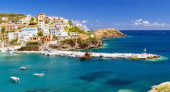
The main towns to visit in Samos are Kokkari, Pythagorean, Heraion and Karlovassi. Charm can be found here by simply wandering the quaint streets and stopping off at cute little cafes and taverns along the way. Heraion holds the iconic temple, dedicated to the Goddess Hera, and the tunnel of Eupalinos is a Roman aqueduct that makes for fun insight to ancient times on the island.
Food and drink in Samos
The food in Samos is influenced by both Greek tradition and migrants. The fruitful landscape also makes a prime foundation for a range of foods Samos has become famous for, extra olive virgin oil is a good example. For meat lovers, baby-goat is a local favourite, roasted and stuffed with potatoes and garlic in a tomato sauce. Another common favourite in Samos is stuffed vegetables; peppers, aubergines and zucchini filled with rice or minced meat, sauteed and baked with herbs and spices.
Samos wine heritage dates back to around 1200 BC and boasts sweet wines famous all over the world, made from the muscat grape. The vineyards in Samos make up a great culture for the locals, and wine tasting makes for a pleasant afternoon in the sun.
A brief history of Samos
Sámos was during the Archaic era among the wealthiest islands in the Aegean and, under the patronage of tyrant Polykrates, home to a thriving intellectual community that included Epicurus, Pythagoras, Aristarchus and Aesop. Decline set in when Classical Athens rose, though Sámos’s status improved in Byzantine times when it formed its own imperial administrative district. Late in the fifteenth century, the ruling Genoese abandoned the island to the mercies of pirates and Sámos remained almost uninhabited until 1562 when it was repopulated with Greek Orthodox settlers from various corners of the empire.
The new Samians fought fiercely for independence during the 1820s, but despite notable land and sea victories against the Turks, the Great Powers handed the island back to the Ottomans in 1830, with the consoling proviso that it be semi-autonomous, ruled by an appointed Christian prince. This period, known as the Iyimonía (Hegemony), was marked by a renaissance in fortunes, courtesy of the hemp, leather-tanning and (especially) tobacco trades. However, union with Greece in 1912, an influx of refugees from Asia Minor in 1923 and the ravages of a bitter World War II occupation followed by mass emigration effectively reversed this recovery until tourism took over during the 1980s.
Vathý
Lining the steep northeastern shore of a deep bay, beachless VATHÝ (often confusingly referred to as “Sámos”) is a busy provincial town which grew from a minor anchorage after 1830, when it replaced Hóra as the island’s capital. It’s an unlikely, rather ungraceful resort and holds little of interest aside from an excellent museum, some Neoclassical mansions and the hillside suburb of Áno Vathý.