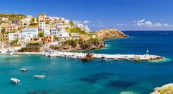
The Pelion peninsula
The hilly PELION PENINSULA confounds every stereotypical image of Greece, with its abundant fruit trees and dense forests and water gurgling up from fountains or aqueducts. Summer temperatures here can be a good 5°C cooler than on the baking plains nearby, and this finger of land is very popular with Greek tourists and more discerning foreign visitors drawn to its pretty villages, excellent beaches and hiking routes.
The peninsula is dominated by Mount Pelion (Mount Pílio; 1651m), below which villages are spread out widely, linked by cobbled paths. The best concentration of traditional communities lies just north and east of Vólos, the main gateway to the region. The west coast down from Vólos to Áfyssos is less memorable, with concentrated development along the Pagasitic Gulf despite no decent beaches. The far south, relatively low-lying and sparsely populated, has just two major resorts – Plataniás and Milína – plus a few inland villages and the picturesque fishing port of Ayía Kyriakí at the extreme southwestern tip.
Pelion legends and food
For the ancients, the lushness of the Pelion made this the site of revelries by the gods and haunt of the mythical centaurs – thus the name Kentavros (Centaur) for various hotels and bars, as well as the rowdy creature’s depictions everywhere.
With its orchards of apple, pear and nut, the Pelion is still one of the most agriculturally prolific areas of Greece. Herbs, fruit, home-made preserves and honey are likely souvenirs. The Pelion boasts a distinct regional cuisine: spedzofáï (sausage and pepper casserole) and gídha lemonáti (goat stew with lemon sauce); seafood is often garnished with krítamo (pickled rock samphire) or tsitsíravla (pickled April-shrubbery shoots), and wine from the Dhimitra Co-op at Néa Anhíalos is widely available.
The Pelion trenáki
A prime west-Pelion attraction is the trenáki, or narrow-gauge railway, which originally ran between Vólos and Miliés. The 60km line, in normal service until 1971, was laid out between 1894 and 1903 under the supervision of engineer Evaristo de Chirico, father of famous artist Giorgio de Chirico (which accounts for the little trains which chug across several of his paintings). To conquer the 2.8-percent gradient and numerous ravines between Áno Lehónia and Miliés, the elder de Chirico designed six multiple-span stone viaducts, tunnels and a riveted iron trestle bridge, all justly considered masterpieces of form and function. The bridge, some 700m west of the terminus below Miliés, spans a particularly deep gorge and can be crossed on a pedestrian catwalk; indeed, following the entire route down to Áno Lehónia is a popular 5hr 30min walk, with occasional springs en route.
You can ride on one of the original Belgian steam locomotives (since converted to diesel), during weekends and holidays Easter–October (daily July–Aug), and several of the belle epoque stations have been restored. The train leaves Áno Lehónia (city bus #5 from Vólos) on the coast at 11am, taking 95min to reach Miliés, from where it returns at 4pm. Tickets are currently €13 adults, €8.50 kids, one-way or round trip, and go on sale at 10.30am (start queuing at 10am), at either Vólos or Áno Lehónia. However, groups often book out the three carriages, so best make enquiries at Vólos station a few days in advance.
The Píndhos Mountains
Continuing west from Metéora, you soon encounter the rugged peaks, forested ravines and turbulent rivers of the Píndhos Mountains. Over the centuries, this range has insulated the communities and culture here from outside interference, securing a large measure of autonomy even under Ottoman rule. Yet, today it’s the mountains themselves that provide the strongest attraction. Their physical beauty is stunning, with limestone peaks, dramatic gorges and dense forest contrasting with stone-built villages and arched packhorse bridges.
Roughly halfway over the mountains stands Métsovo, the most convenient venue for alpine life Greek-style, plus a taste of the local Vlach culture. Down on the plain below is the fascinating lakeside city of Ioánnina, capital of Epirus, the last region of Greece to be liberated from the Turks. Farther to the north, back up in the Píndhos mountains, authentic stone hamlets and the stunning Víkos Gorge provide unforgettable scenery and hiking opportunities.
Take the high road: the Katára Pass
West of Kalambáka, the 1694-m Katára Pass carries the only high-altitude paved road across the central Píndhos Mountains to link the regions of Thessaly and Epirus, which lie on either side. One of the most spectacular drives in the country, this centuries-old route switchbacks through folds in the enormous peaks rising more than 2300m around Métsovo. From November to April the pass is snowploughed – although these days the old, twisty road is entirely optional. Sixty enormous tunnels linked by long viaducts have been bored through the ridges here as part of the recently completed Vía Egnatía expressway, which now smoothly flows all the way to the west coast.
The Vlachs
Europe’s last semi-nomadic peoples the Vlachs have lived in the Píndhos Mountains for centuries. Each summer, the melting of the winter snows finds the vast slopes here coming alive with the sound of bells, as the Vlachs bring their flocks up from the plains to graze in the mountains. Though the ethnicity of the Vlachs (from the ancient Germanic word for “foreigner” Walh) is a subject of much scholarly debate, most claim to be descendants of Roman soldiers stationed here in Classical times, and they speak a Latin-derived, unwritten language similar to modern Romanian. Today, although the Greek government keeps no records of ethnicity, it is estimated that perhaps 40,000 Vlachs live in small communities scattered throughout the Píndhos range, where you can still see shepherds wearing the distinctive goat-skin cape and wielding their fanciful crook. In the remotest areas, traditional Vlach pagan beliefs are only thinly overlaid with the Orthodox faith; many elderly women still have a black cross tattooed on their foreheads, to ward off the evil eye, and their gossip is rife with folktales of sorcery and curses.
Ioánnina
IOÁNNINA, the provincial capital of Epirus, with some 130,000 inhabitants, boasts an idyllic setting, its old town jutting out into the great Lake Pamvótis along a rocky promontory, its fortifications punctuated by spindly minarets. From this base, Ali Pasha “the Lion of Ioánnina” carved from the Turkish domains a personal fiefdom that encompassed much of western Greece and present-day Albania: an act of rebellion that prefigured wider defiance in the Greeks’ own War of Independence.
Although much of the city is modern and undistinguished (albeit home to a thriving university), the old town remains one of the most interesting in Greece. There are stone-built mosques (and a synagogue) that evoke the Ottoman era, and Ali Pasha’s citadel, the kástro, survives more or less intact, its inner citadel, the Its Kale, now a museum park. In the lake, Nissí island has a car-free if overly prettified village, and frescoed monasteries. Ioánnina is also a springboard for visits to the caves of Pérama, among the country’s largest, on the western shore of the lake, and a slightly longer excursion to the very ancient Oracle of Zeus at Dodona. Finally, the city is also the gateway to what is possibly the area’s most rewarding corner, Zagóri.
The Kástro
In its heyday the Kástro’s walls dropped abruptly to the lake, and were moated on their landward (southwest) side. The moat has been filled in, and a quay-esplanade now extends below the lakeside ramparts, but there is still the sense of a citadel, with narrow alleys and bazaar-like shops.
Municipal Ethnographic Museum
Signs inside point to the ethnographic museum, an elegantly arranged collection of Epirot costumes, guns, silver-work and Islamic art, housed in the well-preserved, floodlit Aslan Pasha Tzamí, allowing a rare glimpse inside an intact Greek mosque. It dates from 1618, built on the site of an Orthodox cathedral pulled down in reprisal for a failed local revolt of 1611. The interior retains painted decoration in its dome and mihrab (niche indicating direction of Mecca), as well as a vividly coloured mimber or pulpit, nicely complementing a walnut and mother-of-pearl suite on display in the “Muslim section”.
More poignant is a section devoted to synagogue rugs and tapestries donated by the dwindling Jewish community of about fifty.
The inner citadel (the Its Kale)
Southeast of the Aslan Pasha Tzamí lies the inner citadel, signposted as Its Kale, a transliteration of its Turkish name – a kind of fortress within the fortress. The park-like grounds, with wonderful mountain views from this elevated spot, are occasionally used for concerts after-hours, and there’s a large and pleasant terrace café-restaurant near the entrance, occupying the garrison’s former mess.
Next to the old Fethiye Tzamí (“Victory Mosque”) and its slim, rocket-like minaret – which occupy an upper corner – one of the two Ottoman graves, surmounted by an elegant wrought-iron cage, is probably that of Ali Pasha, while the other contains his first wife Emine and one son. The mosque itself, remodelled by Ali, was built atop the remains of a thirteenth-century cathedral.
Next to the mosque, on the site of Ali’s vanished palace, where Byron was entertained, stands the arcaded so-called Byzantine Museum, a thin, largely post-Byzantine collection. The displays comprise masonry, coins, pottery, icons and colour prints of frescoes from various ages; the only actually Byzantine painting is a fresco fragment of The Betrayal.
A few paces down the hill, in the presumed treasury of Ali Pasha’s seraglio, is the Silverwork Hall, containing important masterpieces of Ioánnina’s centuries-old silver-working tradition.
The old bazaar and Jewish quarter
Apart from the kástro, the town’s most enjoyable district is the old bazaar and Jewish quarter, a warren of narrow lanes and alleys between the citadel’s main gate and Anexartissías avenue bounding it on the south. It retains a cluster of Ottoman-era buildings (including imposing mansions with ornate window grilles and founding inscriptions), as well as a scattering of copper- and tinsmiths, plus the silversmiths who were long a mainstay of the town’s economy. Retail silver outlets cluster either side of kástro’s gate; you’ll find the last traditional tinsmiths at Anexartissías 84, and the last copper-mongers at no. 118–122. Stoas off Anexartissías serving old warehouses, now being gentrified, can also be rewardingly explored.
Nissí island
The island of Nissí in Lake Pamvótis is connected by water buses from the Mólos quay on Platía Mavíli. Only islanders’ cars are allowed, hauled across on a chain-barge to the mainland opposite. The pretty island village, founded during the sixteenth century by refugees from the Máni, is flanked by several monasteries, worthy targets for an afternoon’s visit. By day the main lane leading up from the boat dock is crammed with stalls selling jewellery and kitsch souvenirs. Except at three overpriced waterfront restaurants and another cluster by Pandelímonos, quiet descends with the sun setting vividly over the reed beds that fringe the island.
Lake Pamvótis itself is certainly idyllic-looking enough, and it’s the region’s largest lake, but runoff pollution is an ongoing problem and most locals do not advise either swimming in its waters or eating its fish.
The Pérama caves
Some 5km north of Ioánnina, the village of PÉRAMA claims to have Greece’s largest system of caves, extending for kilometres beneath a low hill. They were discovered during late 1940 by locals attempting to find shelter from Italian bombing raids. The one-hour mandatory tours of the complex are primarily in Greek (commentary repeated in passable English) and make some effort to educate, though there are the inevitable bawdy nicknames for various suggestively shaped formations.
Dodona: the Oracle of Zeus
DODONA, 22km southwest of Ioánnina in a broad, mountain-ringed valley, comprises the ruins and large theatre of the ancient Oracle of Zeus, Greece’s first oracle, some of the site dating back as far as four millennia.
The impressive theatre was built during the reign of King Pyrrhus (297–272 BC), and was one of the largest in Greece, rivalled only by those at Argos and Megalopolis. The Romans added a protective wall and a drainage channel around the orchestra as adaptations for their blood sports. What’s now visible is a meticulous late nineteenth-century reconstruction. Almost all except the stage area is now off-limits, though it’s worth following a path around to the top of the cavea (seating curve) to fully savour the glorious setting, looking across a green, silent valley to Mount Tómaros. A grand entrance gate leads into the overgrown acropolis, with Hellenistic foundations up to 5m wide.
Beside the theatre, tiered against the same slope, are the foundations of a bouleuterion, beyond which lie the complex ruins of the Sanctuary of Zeus, site of the oracle itself. There was no temple per se until late in the fifth century BC; until then, worship had centred upon the sacred oak, inside a circle of votive tripods and cauldrons. The remains you can see today are adorned with a modern oak tree planted by a helpfully reverent archeologist. Nearby is a useful placard detailing the entire site.
Dodona occasionally hosts musical and ancient drama performances on summer weekends, though sadly since 2000 these are staged on modern wooden bleachers rather than in the ancient theatre.
Ali Pasha – the Lion of Ioánnina
As an “heroic rebel”, the Muslim Albanian Ali Pasha assumes an ambivalent role – for his only consistent policy was that of ambition and self-interest. As frequent as his attacks on the Ottoman authorities were, he also engaged in acts of appalling savagery against his Greek subjects. Despite this, he is still held in some regard by locals for his perceived role as a defier of Istanbul, the common enemy – folk postcards of the man abound, and a platía in the citadel is named after him.
Ali was born in 1741 in Tepelene, now in modern Albania, and by 1787 had been made pasha of Tríkala as a reward for his efforts in the war against Austria. His ambitions, however, were larger, and the following year he seized Ioánnina, an important town since the thirteenth century, with a population of 30,000 – probably the largest in Greece at the time. Paying perfunctory and sporadic tribute to the sultan, he operated from here for the next 33 years, allying himself in turn, as strategy required, with the Ottomans, the French or the British.
In 1809, when his dependence upon the sultan was nominal, Ali was visited by the young Lord Byron, whom he overwhelmed with hospitality and attention. Byron, impressed for his part with the rebel’s daring and stature, and the lively revival of Greek culture in Ioánnina, commemorated the meeting in Childe Harold. This portrait that he draws, however, is ambiguous, since Byron well knew that behind Ali’s splendid court and deceptively mild countenance were “deeds that lurk” and “stain him with disgrace”.
Ali met a suitably grisly end. In 1821, the Ottoman sultan resolved to eliminate Ali’s threat to his authority before tackling the Greek insurgency, and he sent an army of 50,000 to capture him. Lured from the security of Ioánnina citadel with false promises of lenient surrender terms, he was ambushed, shot and decapitated, his head sent to Istanbul. The rest of Ali supposedly lies in the northeast corner of the inner citadel.
Zagóri and the Víkos Gorge
Few parts of Greece are more surprising or more beguiling than the part of the Píndhos mountains known as ZAGÓRI. A wild, thinly populated region, it lies just to the north of Ioánnina. The beauty of its landscape is unquestionable: dense forest and rugged mountains are furrowed by foaming rivers and dotted with traditional villages (the Zagorohória), many sporting grand stone houses or arhondiká, dating from the late eighteenth century. Here, also, you can seek out evocative ancient monasteries set in improbably remote spots. Wildlife is impressive too: there’s good birdwatching, increasing numbers of wolves, plus legally protected brown bears.
The best way to enjoy the countryside is by hiking the numerous paths connecting the villages. The most accessible and rewarding target is the magnificent UNESCO-protected Víkos Gorge, while mounts Gamíla and Smólikas provide several days of serious trekking. Even if you don’t plan on hiking, the area deserves some time. Its remoteness, traditional architecture and scenery all constitute a very different Greece to the popular tourist stereotype and, despite growing popularity, the area remains relatively unspoilt.
Monodhéndhri
Near the south end of the gorge, at 1150m elevation, stands handsome MONODHÉNDHRI, the main accommodation base in the area. The village survived World War II more or less intact – though it’s now slightly spoilt by tourist shops and parked coaches. Just before the flagstoned platía with its giant tree, the seventeenth-century church of Áyios Minás is locked, but the narthex, with fine eighteenth-century frescoes, is open. The wide, artlessly modern kalderími leading from the far end of the platía reaches, after 900m (not “600m” as signed) the eagle’s-nest monastery of Ayía Paraskeví (built 1412), teetering on the brink of the gorge (there’s a small viewing platform just behind) and now empty, though left open. If you’re extremely sure-footed and have a head for heights, continue around the adjacent cliff face along an exceedingly narrow and dangerous path to a stair-trail climbing to Megáli Spiliá, a secluded cave where villagers once barricaded themselves in times of danger. The views over the gorge en route are spectacular from a natural balcony, with all of Víkos spread vertiginously at your feet.
The Pápingo villages
MEGÁLO PÁPINGO is the larger of the two paired Pápingo villages, comprising two distinct quarters of 25 or so houses each along a tributary of the Voïdhomátis. It has served as the location for Jonathan Nossiter’s 2000 film Signs and Wonders, starring Charlotte Rampling, plus countless Greek advertising shoots. Even before this, Megálo was a haunt of wealthy, trendy Greeks, making it a dubious target in peak season, though it is still delightful at other times. The fact that large coaches can’t scale the steep hairpin road from the Voïdhomátis valley has made all the difference between here and Monodhéndhri; in peak season you must leave cars at the outskirts.
Megálo Pápingo is linked to its smaller namesake, Mikró Pápingo, by a 3km surfaced road; walkers should take the marked path off the road, via a historic bridge, which short-cuts the journey to half an hour. If you do take the road, just before the bend – at an obvious spot adorned by low masoned walls – you can detour to some natural swimming pools. Just below the church, in Mikró Pápingo, the WWF maintains an information centre (Mon, Tues, Thurs & Sun 10.30am–5.30pm; Fri, Sat & hols 11am–6pm; free) with worthwhile exhibits on the human and natural history of Pápingo and environs.
Vítsa and the Skála Vítsas
VÍTSA (Vezítsa), 2km below Monodhéndhri, is to many tastes less claustrophobic and more attractive than Monodhéndhri. There’s also access to the gorge via the signposted Skála Vítsas, a half-hour’s gentle descent from the platía along the Z9 – mostly on engineered stair-path – to the handsome single-arched Misíou bridge; from there one can continue upstream to Kípi village via the O3 path, or downstream along the heart of the gorge.
Dhílofo
From either Vítsa or the Misíou bridge, the Z15 leads south to DHÍLOFO, one of the most handsome Zagorian villages. The village has road access (though cars must be left at the outskirts). Alternatively it makes for a rewarding hike. The path-start in Vítsa is trickier to find than the branch leading from the bridge, but once done it’s a twenty-minute descent to a stream bed, where the Misíou branch links up, then a climb along a crumbled kalderími which peters out in flysch badlands. After another stream crossing, the path resumes before becoming a track to the outskirts of Dhílofo, just over an hour along.
Eláti
The village of ELÁTI (Boúltzi) is rather distant from the gorge, but there are fine views north to the peaks of Gamíla. From Dhílofo, walkers can continue down to Áyios Minás chapel on the main road and thence to Eláti on the Z24, but nearly half the way (90min) is along asphalt or bulldozer track, so you may as well come by car.
Dhíkorfo and the Kaloutás bridge
DHÍKORFO (Tzódhila) proves a beauty with its grand houses and unusual, minaret-like belfry of Áyios Minás church. Beyond the village the chief attraction is the enormous triple-arched bridge below Kaloutás, about 250m off the paved road by dirt track. All villages past Kaloutás were destroyed during World War II, but the road continues paved to Miliotádhes and thence the old Ioánnina–Métsovo highway – a useful short cut.
Áno Pedhiná
ÁNO PEDHINÁ (Soudhená), 3km west of Vítsa and Monodhéndhri, offers a few places with rooms and some superior hotels. At the base of the village stands the restored convent of Evangelístria, currently untenanted. Should you gain admission, you’ll see the katholikón’s magnificent carved témblon and vivid, cleaned frescoes from 1793, though the structure is much older. Nearby Káto Pedhiná is headquarters for worthwhile activity organizer
Compass Adventures.
Hiking the Víkos Gorge
The Víkos Gorge cuts right through the limestone uplands of Mount Gamíla for 20km, separating the villages of western and central Zagóri. With walls almost 1000m high in places, it’s quite equal to the famous Samarian gorge in Crete, and a hike through or around it is probably the highlight of a visit to the Zagóri.
Despite the gorge’s popularity with hikers, and periodic bouts of trail maintenance, it’s worth emphasizing that it is not a Sunday stroll. Bring proper, over-the-ankle boots and a leak-proof water container and walking poles or a stick (also useful for warding off guard dogs and belligerent cows). The best maps for the region are produced by Anavasi Editions . Check conditions in advance of setting out. During April or early May, snowmelt often makes the Monodhéndhri end impassable, and during a rainstorm the sides of the gorge are prone to landslides.
The route
The most-used path down to the gorge begins beside the Áyios Athanásios church in Monodhéndhri; a sign promises fairly accurate walking times of four-and-a-half hours to Víkos village, six hours to either of the Pápingo villages. Once past Monodhéndhri’s municipal amphitheatre, the path is cobbled for most of the forty minutes down to the riverbed, whose stony course you follow for another few minutes before shifting up the west (true left) bank, reaching the best viewpoint at a saddle ninety minutes from the village.
The entire route is waymarked, sometimes faintly, by red-paint dots and white-on-red stencilled metal diamonds with the legend “O3”. This refers to a long-distance path, which begins south of Kípi at Lynkiádhes on Mount Mitsikéli, traverses Mount Gamíla and ends beyond Mount Smólikas. However, the surface underfoot is arduous, with some boulder-hopping in the gorge bed, metal or felled-branch ladders getting you over tricky bits on the bank, plus slippery, land-slid patches.
About two hours out of Monodhéndhri you draw even with the Mégas Lákkos ravine, the only major breach in the east wall of the gorge; a spring here has been piped to make it more usable in summer. Another thirty minutes’ level walking takes you past the small, white shrine of Ayía Triádha; a further half-hour (around 3hr from Monodhéndhri) sees the gorge begin to open out and the sheer walls recede.
As the gorge widens you must make a choice. Continuing straight, the best-defined path takes you past the side trail to beautifully set eighteenth-century Kímisis Theotókou chapel (unlocked; excellent frescoes well worth the 15min round-trip detour). Beyond here, the route becomes a well-paved kalderími, climbing up and left to Víkos (Vitsikó; 870m elevation), four-plus hours from Monodhéndhri and also accessible by a 5km paved road from Arísti. This underrated village has two inns, and up on the square, with its exceptionally handsome church of Áyios Trýfon, a good restaurant.
Most walkers, however, prefer to follow the marked O3 route to the two Pápingo villages, crossing the gorge bed at the Voïdhomátis springs, some three-and-a-half hours from Monodhéndhri. It’s about two hours’ walk from the springs up to Mikró Pápingo, slightly less to Megálo, with the divide in the trail nearly ninety minutes above the riverbed crossing. After an initial steep climb, there’s a fine view down into the gorge near some weathered, tooth-like pinnacles, before the trail traverses a stable rockslide to the fork. Should you be reversing this route, the path-start in Mikró Pápingo village is signposted bilingually, and marked by a fancy stone archway in Megálo Pápingo.
The oak tree oracle
“Wintry Dodona” was mentioned by Homer, and religious activities here appear to have begun with the first Hellenic tribes who arrived in Epirus around 1900 BC. Herodotus records that the oracle was founded after the mythic arrival of a peleiae (either “dove” or “old woman” in ancient Greek) from Egypt, said to have alighted on an oak tree. In any case, the oak tree was certainly central to the cult with the oracle speaking through the rustling of its leaves, amplified by copper vessels suspended from its branches. These sounds would then be interpreted by frenzied priestesses and/or priests, who allegedly slept on the ground and never washed their feet.
Many oracular inscriptions were found when the site was first systematically dug in 1952, demonstrating not only the oracle’s lingering influence even after its eclipse by Delphi, but also the fears and inadequacies motivating pilgrims of the era in such questions as: “Am I her children’s father?” and “Has Peistos stolen the wool from the mattress?”
West Coast Greece
Starting just south of where the Vía Egnatía expressway ends, the west coast has some attractive beaches between Igoumenítsa and Préveza, among the best on the mainland outside of Mount Pílio. Igoumenítsa itself, the capital of Thesprotía province, is a purely functional ferry port. Attractive Párga, the most established beach resort heading south, gets super packed-out in summer and at Easter, so is best left for June or September visits. Just inland, there are worthwhile detours from the main route south: the intriguing Nekromanteion of Acheron evokes the legendary entrance to Hades; and the vast ruins of Nikopolis break the journey to Préveza, a low-key provincial capital at the mouth of the marshy Amvrakikós gulf. Down along the south coast, Mesolónghi is considered by Greeks as a sacred spot for being where Lord Byron died while doing his part to liberate Greece from the Ottomans.
Mesolóngi and around
Mesolóngi (Missolongi), for most visitors, is irrevocably associated with Lord Byron, who died here to dramatic effect during the War of Independence. Otherwise it’s a fairly shabby and unromantic place: rainy from autumn to spring, and comprised largely of drab, modern buildings between which locals enthusiastically cycle along a flat grid plan. To be fair, the town has been spruced up, especially in the centre, but if you come here on pilgrimage, it’s still best to move on the same day, most likely to Lefkádha island or the Peloponnese.
Gate of the Sortie
You enter the town from the northeast through the Gate of the Sortie, named after the April 12, 1826 break-out by nine thousand Greeks, ending the Ottomans’ year-long siege. In one desperate dash they quit Mesolóngi, leaving a group of defenders to destroy it – and some three thousand civilians not capable of leaving – by firing the powder magazines. But those fleeing were betrayed, ambushed on nearby Mount Zygós; fewer than two thousand evaded massacre or capture and enslavement by an Albanian mercenary force.
Garden of Heroes
Just inside this gate, on the right, partly bounded by the remaining fortifications, is the Kípos Iróön, or “Garden of Heroes” – signposted in English as “Heroes’ Tombs” – where a tumulus covers the bodies of the town’s anonymous defenders. Beside the tomb of Souliot commander Markos Botsaris is a statue of Byron, erected in 1881, under which – despite apocryphal traditions – is buried neither the poet’s heart nor lungs. Byron might conceivably have been offered the throne of an independent Greece: thus the relief of his coat of arms with a royal crown above. Among the palm trees and rusty cannon loom busts, obelisks and cenotaphs to an astonishing range of American, German and French Philhellenes, those Romantics who strove to free the Classical Greece of their ideals from the barbaric thrall of the Ottomans.
Museum of History and Art
Back on the central square, the Neoclassical town hall houses the small Museum of History and Art devoted to the revolution, with some emotive paintings on the upper floor (including a copy of Delacroix’s Gate of the Sortie), reproductions of period lithographs and a rather disparate (and desperate) collection of Byronia on the ground floor. Pride of place, by the entrance, goes to an original edition of Solomos’s poem Hymn to Liberty, now the words of the national anthem.
The lagoon
More interesting than any town sight is a walk across the Klísova lagoon, past two forts that were vital defences against the Ottoman navy. The lagoon, with its salt-evaporation ponds and fish farms, attracts a variety of wading birds, especially in spring.
Tourlídha
A causeway extends 4km from Mesolóngi to the open sea at TOURLÍDHA, a hamlet of wood-plank and prefab summer cottages on stilts, plus a few tavernas. If you can stomach the intermittent stench from the nearby salt-ponds, there’s a packed-sand beach to swim from, with showers and a few café-bars. Makes a picturesque, funky outing if you’re visiting Mesolóngi.
Byron in Mesolóngi
Byron has been a Greek national hero ever since he became involved in the country’s struggle for independence. Almost every town in the country has a street – Výronos – named after him; not a few men still answer to “Vyron” as a first name. He first passed through in 1809 when tyrannical local ruler Ali Pasha was at the height of his power, and the poet’s tales of intrigue sent a shiver down romantic Western spines.
Later, in January 1824, Byron made his way to Mesolóngi, a squalid, inhospitable southwestern port amid lagoons – but also the western centre of resistance against the Ottomans. The poet, who had by then contributed his personal fame and fortune to the war effort, was enthusiastically greeted with a 21-gun salute, and made commander of the five-thousand-strong garrison, a role as much political as military. The Greek forces were divided into factions whose brigand-chieftains separately and persistently petitioned him for money. Occasionally Byron despaired: “Here we sit in this realm of mud and discord”, read one of his journal entries. But while other Philhellenes returned home, disillusioned by the fractious, larcenous Greeks, or worn out by quasi-tropical Mesolóngi, he stayed.
On February 15 Byron caught a fever, possibly malaria, and two months later died; ironically, he became more valuable to the Greek cause dead than alive. News of the poet’s demise, embellished to heroic proportions, reverberated across northern Europe; arguably it changed the course of the war in Greece. When Mesolóngi fell again to the Ottomans in spring 1826, there was outcry in the European press, and French and English forces were finally galvanized into sending a naval force that unintentionally engaged an Egyptian fleet at Navarino, striking a fatal blow against the Ottoman navy.
Delphi
The inevitable magnet of the central province of Stereá Elládha is Delphi, 175km northwest of Athens. If you have your own transport, there are ample rewards in approaching it along the old road to Thebes, and you could also easily include the Byzantine monastery of Ósios Loukás. Legendary Mount Parnassós above Delphi offers skiing and walking opportunities depending on the season, while to the south, on the Gulf of Korínthos, the port towns of Galaxídhi and Náfpaktos are good for a seaside sojourn. Further east, Áyios Konstandínos provides access to the island of Évvia, while heading inland brings you to Lamía and the mountainous Karpeníssi Valley.