Brief history
It’s generally held that sophisticated Olmec influence – emerging first in Mexico and spread along the coast – shaped both Ocós and Iztapa cultures, which thrived here after 1500 BC. These were small, village-based societies that developed considerable skills in the working of stone and pottery.
Between 400 and 900 AD, parts of the coastal plain were overrun by the Pipil, who migrated south from Mexico, bringing new architectural styles and artistic skills. They established settlements with compact ceremonial centres and rubble-filled pyramids and traded cacao. The first Spaniards to set foot in Guatemala did so on the Pacific coast. In colonial times indigo and cacao were cultivated and cattle ranches established, but the inhospitable climate and accompanying diseases took their toll, and for the most part the region remained a miserable backwater. It was only after independence that commercial agriculture began to dominate. By the early twentieth century, the area was important enough to justify the construction of two railways to the coast and a line to the Mexican border.
Today the coastal strip is the country’s most intensely farmed region, with entire villages effectively owned by vast fincas. There’s a little domestic tourism but in general it’s agribusiness – palm oil, bananas and sugar on the coast and coffee on the Pacific slope – that dominates the local economy.
Along the Pacific Coastal Highway
Heading east of the border you pass a succession of dull, incessantly hot, purely commercial towns. Retalhuleu is slightly more attractive than most, close to which are the intriguing Maya-Olmec ruins of Takalik Abaj. North of Retalhuleu you’re within easy reach of the terrific theme parks of Parque Acuático Xocomil and Parque Xetulul.
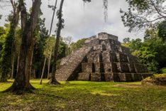
Takalik Abaj
The archeological site of Takalik Abaj has cast fresh light on the development of early Maya civilization, particularly the influence of Olmec culture. The city presided over trade routes along the Pacific littoral, controlling the movement of jade, cacao and obsidian. An unlooted Maya royal grave was uncovered in 2002, and excavations are ongoing. First settled around 1800 BC, early ceremonial buildings and monuments were executed in Olmec style between 800 and 400 BC, including the characteristic pot-bellied humans with swollen eyelids. But by the late Preclassic period, Maya-style carvings of standing rulers were beginning to replace Olmec art. Later in the Classic era some of the Maya World’s most exquisite jade masks were created here – they now reside in Guatemala City’s Museo Nacional de Arqueología y Etnología.
Theme parks
Parque Acuático Xocomil
On the main road to Quetzaltenango, Parque Acuático Xocomil is a superb theme park landscaped into the foothills of the highlands. It’s a vast complex containing 1.2km of water slides, wave pools and artificial rivers amidst grounds replete with Maya temples and copious greenery.
Parque Xetulul
Neighbouring Parque Acuático Xocomil, Parque Xetulul is divided into different zones, with the Plaza Chapina having re-creations of famous Guatemalan buildings, the Plaza España showcasing a galleon, and Plaza Francia boasting replicas of Parisian structures such as the Gare de France. The park has some terrific rides, including the thrilling La Avalancha rollercoaster and, like its sister complex, is clean, well run and extremely popular with Guatemalan families.
From Escuintla to El Salvador
Heading east from Escuintla you skirt a Guatemalan safari park and then the coastal highway passes TAXISCO, from where you can access La Avellana, which has boats to Monterrico. Beyond here, lonely side roads lead to isolated beaches, including Las Lisas.
Santa Lucía Cotzumalguapa and around
East along the speedy Carretera al Pacífico past Mazatenango you’ll soon approach SANTA LUCÍA COTZUMALGUAPA, an uninspiring Pacific town a short distance north of the highway. The only reason to visit the area is to take in some (minor) nearby Pipil and Maya archeological sites, scattered in the surrounding cane fields, and the colossal Olmec carved figures at nearby La Democracia or the surf at Sipacate to the south. Getting to them is not easy unless you rent a taxi however.
Surfing
The low-key village of SIPACATE is located inside the Parque Natural Sipacate-Naranjo, a mangrove coastal reserve. The black sand beach here is separated from the village by the black waters of the Canal de Chiquimulilla; boats ferry a steady stream of passengers to the waves. The best surf here is about 5km to the east on the empty sands of neighbouring Paredón beach, where a great new hotel has kick-started a Guatemalan surf scene. Waves average two metres and are most consistent between December and April, though conditions are usually tough for beginners. There are surf reports posted on the Paredón Surf House website.