What to see in Northern Vietnam
The little-travelled provinces of Ha Giang and Cao Bang also deserve attention, especially the stunning scenery and ethnic minorities in the Dong Van Karst Plateau Geopark, which occupies over 2300 square kilometres of Ha Giang province. Cao Bang’s attractions include the pretty Ban Gioc Falls and Hang Pac Bo, where Ho Chi Minh plotted his country’s liberation. The northeast region also features Ba Be National Park, where Vietnam’s largest natural lake nestles amid forested limestone crags and impenetrable jungle.
Not surprisingly, infrastructure throughout the northern mountains is poor: facilities tend to be thin on the ground, and some roads are in terrible condition. However, this area is becoming increasingly popular with tourists as Hanoi’s tour agents organize new tours and independent travellers venture into uncharted terrain by jeep or motorbike. New homestays are also opening all the time, especially in Ha Giang province.
Cities to Visit in Northern Vietnam
The obvious, most popular city to visit in Northern Vietnam would be Hanoi, the capital. With roughly 7,600 million inhabitants Hanoi is a hub of life made up of colonial buildings and ancient pagodas. Famous for its well-made silk and handicrafts, it is a must-see when in the country. Plastic chairs and tables crowd the small streets at night, surrounded by hungry locals and tourists enjoying delicious cuisine from the food stalls. One of the most ancient capitals of the world with heavy influences from China, France and Russia, Hanoi is a city with much to offer. Motorcycle tours are thriving in the city, with short trips to beautiful landscapes within spitting distance and local tour guides who show tourists hidden gems that might otherwise go unnoticed by visitors.
Around 175km from Hanoi, sits Ha Long Bay. A much smaller city located on the Northern coast of Vietnam. Famous for its emerald waters and hundreds of towering rainforest islands dotted around the bay, it is no wonder that it has been deemed a natural wonder of the world. Popular for activities such as scuba diving, rock climbing and kayaking it is a place many flock too to get active whilst enjoying the idealistic scenery. It is also a common theme to partake in boat tours around the bay, where often tourists will venture to cave formations and hidden temples.
Sa Pa
Most people who visit Northern Vietnam stop off in Sa Pa. The town provides a great base for trekking and visiting some of the region’s minority villages. The town can make for a much-needed breath of fresh air after the humidity and chaos of Hanoi. There are also great views of Mount Fan Si Pan and the surrounding mountains, especially from the cable car. Discover more about Sa Pa.
Bac Ha
The small town of Bac Ha, nestling in a high valley 40km northeast of Highway 7, makes a popular day-excursion from Sa Pa. There’s little to see in the town itself except on Sunday, when villagers of the Tay, Dao, Nung, Giay and above all Flower Hmong ethnic minorities trek in for the lively market. At 1200m above sea level compared to Sa Pa’s 1600m, Bac Ha is less spectacularly beautiful, although it’s still scenic, with cone-shaped mountains bobbing up out of the mist, and it’s also much less touristy, giving out a workaday sense of a bustling agricultural community rather than an alpine resort.
Bac Ha provides a stark contrast to Sa Pa, with little in the way of tourist facilities beyond a few guesthouses. As Sa Pa becomes saturated with tourists seeking out a more authentic experience, so Bac Ha has attempted to emulate Sa Pa’s success by developing its own trekking business focused around the nearby rural markets. For the moment, however, it lacks sufficient infrastructure – which, in many ways, is the key to its charm.
If you’re travelling independently it’s worth spending a whole weekend in Bac Ha, in order to take in the rustic and colourful market at Can Cau on Saturday. Bac Ha also makes a good base for trips out to the surrounding Flower Hmong villages of Ban Pho and Coc Ly.
The Sunday market
The Sunday market, the town’s one big attraction, gradually fills up from 8 to 10am, and from then till lunchtime it’s a jostling mass of colour, mostly provided by the stunningly dressed Flower Hmong women looking for additional adornments to their costume. The scene is filled out with a sizeable livestock market, meat and vegetable sellers, wine sellers and vendors of farming implements. The town returns to a dusty shadow of its former self by 5pm when the ethnic tribes return to their outlying villages.
Hoang A Tuong Palace
At the northern end of town, on the left along the main road, you’ll find the remarkable folly of Hoang A Tuong, formerly known as Vua Meo, or Cat King House. Two storeys of pure wedding cake surround a courtyard built in 1924 by the French as a palace for a Hmong leader, Vuong Chiz Sinh, whom they had installed as the local "king" (Meo, or "Cat" in Vietnamese, is a disparaging term formerly applied by Vietnamese and French to the Hmong). The building is now a tourist information office, with a few displays of local ethnic dress and a shop selling hilltribe gear.
The Northwest Loop
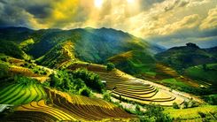
Vietnam’s most mountainous provinces lie immediately west of the Red River Valley, dominated by the country’s highest range, Hoang Lien Son. Right on the border where the Red River enters Vietnam sits Lao Cai Town, a major crossing point into China and gateway to the former hill station of Sa Pa and nearby Bac Ha, both now firmly on the tourist map for their colourful minority groups and weekly markets. From Sa Pa a road loops west across the immense flank of Fan Si Pan, the country’s tallest peak, to join the Song Da (Black River) Valley running south, through the old French garrison towns of Muong Lay (formerly Lai Chau) and Son La, via a series of dramatic passes to the industrial town of Hoa Binh on the edge of the northern delta. The only sight as such is the historic battlefield of Dien Bien Phu, close to the Laos border, but it’s the scenery that makes the diversion worthwhile. Throughout the region, sweeping views and mountain grandeur contrast with ribbons of intensively cultivated valleys, and here more than anywhere else in Vietnam the ethnic minorities have retained their traditional dress, architecture and languages. After Sa Pa, the most popular tourist destination in these mountains is Mai Chau, an attractive area inhabited by the White Thai minority, within easy reach of Hanoi.
Dien Bien Phu
South of Muong Lay the road splits: Highway 6 takes off southeast to Tuan Giao and is the shortest route to Son La; Highway 12 ploughs on south for more than 100km (about 3–4hr), making slow progress at first but then zipping through the second 50km, to the heart-shaped valley of Dien Bien Phu, scene of General Giap’s triumph in a battle that signalled the end of French Indochina. Though the town’s trickle of tourists tend to be French history buffs, it’s starting to become more popular as a base for trips to local minority villages: the valley’s population is predominantly Thai (53 percent), while the Viet are concentrated in the urban area. With the recent opening of the border to foreigners, it’s also being used as an alternative gateway to Laos.
Dien Bien Phu Victory Museum
On the right-hand side as you head south out of town, the museum is set back slightly from the road. The displays of weaponry include American-made guns of World War II vintage captured from French troops. Alongside them languish Viet Minh guns, also American-made but newer: these were booty from the Korean War which came via China into Vietnam, to be dragged up the battlefield’s encircling hills. Familiar photos of the war-torn valley become more interesting in context, as does the scale model where a video describes the unfolding catastrophe – the message is perfectly clear, even in Vietnamese. To the left of the main museum is a small room displaying outfits of the ethnic minorities that live in the region.
Viet Minh Cemetery
Directly opposite the museum, some of the fallen heroes are buried under grey marble headstones marked only with a red and gold star. In 1993 an imposing imperial gateway and white-marble wall of names was added in time for the fortieth anniversary of the battle. The outside of this wall features bas-reliefs in concrete of battle scenes.
Hill A1
A small hill overlooking the cemetery, known as Hill A1 to the Vietnamese and as Eliane 2 to French defenders, was the scene of particularly bitter fighting before it was eventually overrun towards the end of the battle. You can inspect a reconstructed bunker on the summit and various memorials, including the grave of a Viet Minh hero who gave his life while disabling the French tank standing next to him, and you also get a panorama over the now peaceful, agricultural valley.
The Battle of Dien Bien Phu
More than fifty years on, the Battle of Dien Bien Phu remains one of the most significant military conflicts of the twentieth century, with its importance in Vietnam’s struggle for independence commemorated in nearly every town by a street named in honour of that famous victory.
De Castries’ bunker
There’s little to see at the last battle site, a reconstruction of de Castries’ bunker, located on a dusty country road across the river a couple of kilometres from central Dien Bien Phu; Captured tanks, anti-aircraft guns and other weaponry rust away in the surrounding fields. Carry on past the bunker and you’ll come to a concrete enclosure with a memorial to "Those who died here for France".
Son La
Son La’s welcoming, low-key charm is enhanced by its valley-edge setting, and it merits more than the usual overnight stop. If time allows, there’s enough of interest to occupy a few days, taking in the old French prison and a nearby cave, as well as making forays to nearby minority villages on foot or by motorbike.
Certain minority villages stage events for tour groups, such as traditional Thai dancing or supping the local home brew, a sweet wine made of glutinous rice; it’s drunk from a communal earthenware container using bamboo straws, and hence named ruou can, or stem alcohol. The major part of Son La lies off the highway, straggling for little more than a kilometre along the west bank of the Nam La River.
The French prison
Son La’s principal tourist sight is the French prison, which occupies a wooded promontory above To Hieu and offers good views over town. The two turn-offs from the highway are both marked with chunky stylized signs suggesting incarceration; walk uphill to find the prison gates and an arched entrance, still announcing "Pénitencier", leading into the main compound. This region was a hotbed of anti-French resistance, and a list of political prisoners interred here reads like a roll call of famous revolutionaries – among them Le Duan and Truong Chinh, veteran Party members who both went on to become general secretary. Local hero To Hieu was also imprisoned for seditionary crimes but he died from malaria while in captivity in 1944. Most of the buildings lie in ruins, destroyed by a French bombing raid in 1952, but a few have been reconstructed, including the two-storey kitchen block (bep), beneath which are seven punishment cells. Political prisoners were often incarcerated in brutal conditions: the two larger cells (then windowless) held up to five people shackled by the ankles. Behind the kitchens, don’t miss the well-presented collection of prison memorabilia. Enter the second arched gate and upstairs in the building on your right you’ll find an informative display about the dozen or so minorities who inhabit the area, including costumes, handicrafts, jewellery and photos.
Que Lam Ngu Che Cave
The cave most convenient to Son La is Que Lam Ngu Che Cave, which is situated just north of the town centre and has a small shrine inside surrounded by strange formations in the rock. A five hundred-year-old poem written by King Le Thai Tong carved into the stone remains visible today on the outside of the cave. You can go there alone – just look for the sign 150m as you head north out of town, or a guide from the Trade Union Hotel will take you for a small fee.
Ban Mong
An interesting destination for a day’s trek or visit by motorbike is Ban Mong, a Black Thai village six scenic kilometres along a luxuriant valley south of Son La. The houses of this village are solid, wooden structures surrounded by gardens of fruit trees rather than vegetables. The women of the village usually wear their hair piled up high on their head and secured with a head-dress, on top of which they often wear a precariously-perched crash helmet. The dress of the Black Thai women is particularly striking – especially the brightly embroidered headscarves that they drape over their long hair piled up in huge buns. Their tight-fitting blouses with rows of silver buttons, often in the shape of butterflies, are also distinctive. In colder weather, many wear a green, sleeveless sweater over the blouse, or a modern jacket in pink, blue, green or maroon.
On to Mai Chau valley
From Son La Highway 6 climbs east, passing Yen Chau – a town famed for its fruit – and some very pretty Black Thai villages on the right after about 80km, particularly La Ken, which can be visited by crossing swaying suspension bridges over the river. With your own transport, you could make a detour about 20km west over rolling hills to the Chi Day Cave, a popular pilgrimage site for Vietnamese; look for a right turn about 36km south of Son La. The main road from Son La climbs onto a thousand-metre-high plateau where the cool climate favours tea and coffee cultivation, mulberry to feed the voracious worms of Vietnam’s silk industry and herds of dairy cattle, initially imported from Holland, to quench Hanoi’s thirst for milk, yoghurt and ice cream. Just less than 120km out of Son La, the sprawling market town of Moc Chau provides a convenient place for a break. For the next 4km heading towards Hanoi, the road is dotted with stalls selling local milk products such as three kinds of flavoured milk, thick home-made yoghurt and blocks of condensed milk (which they advertise as chocolate when cocoa is added), as well as green tea. The rigid lines of tea bushes that border the road round Moc Chau create curious patterns, and though there are few side roads, this is a region in which some might want to linger. Most, however, head on down Highway 6, through valleys where the Hmong live in distinctive houses built on the ground under long, low roofs, and surrounded by fruit orchards, to Mai Chau, which lies up a side valley south of Highway 6.
Mai Chau
The minority villages of the Mai Chau Valley, inhabited mainly by White Thai, are close enough to Hanoi (135km) to make this a popular destination, particularly at weekends when it’s often swamped with large groups of students. The valley itself, however, is still largely unspoilt, a peaceful scene of pancake-flat rice fields trimmed with jagged mountains.
Mai Chau is the valley’s main settlement – a friendly, quiet place that has a bustling morning market frequented by minority people who trek in to haggle over buffalo meat, star fruit, sacks of tea or groundnuts.